

Last year a bunch of veteran Triple Crown riders and I did the test ride of this event. It was a challenging day as a storm had just passed and the usual wind conditions were much worse. We had gale force winds and dust most of the day but it was an incredible experience just the same with beautiful scenery all day.
The event was moved to a month earlier for the Inaugural
event this year and it paid off. We had absolutely perfect conditions.
I carpooled this year with my good friends John Clare and
his wife Melinda. We had a great and entertaining ride up to Lone Pine. The
desert was green this year which was amazing and there were wild flowers
popping up everywhere.
This was going to be John's 100th, (yes 100th),
Triple Crown Double Century!
I was really excited for him.
A whole bunch of us were planning on sharing this epic milestone with
John. There was an epic turnout for an inaugural event. Over 100 riders!
The course:
The event starts in
the beautiful town of Lone Pine California, a very historic town on
Highway 395 at the foot of the majestic Mount Whitney.
The event starts with
a spin south on the 395 for 37 miles before turning around at Coso Junction and heading back up 395. We then turn toward the Death Valley west
entrance on Highway 190 along the south side of Owens Lake.
We turn around at the
Death Valley entrance and roll around the east side of Owens Lake for lunch at
the historic town of Keeler, Ca.
We then continue on
Highway 136 along the lake back to Lone Pine.
Its then south again
on the 395 for a few miles to Lubken Canyon Road for a stiff climb to
Horseshoe Meadows Road. We climb south then turn around to Whitney Portal road
before heading back to Lone Pine again.
One final 57 mile loop
around the lake, this time in a clockwise direction and we return to finish the
ride.
Part one: Start to Coso Junction. 37.5 miles.
John and I decided to start at the late start time around
6 am.
There were about 9 of us that ended up riding together all day and into
the night. John, myself, Vic Cooper, Margaret Benson, Ed Gallegos, Tony
Musorafite, Rick Jacobson and David Slaton.
John and I went to the start and when we rolled we saw that
a few had not left the hotel so we went back and waited for them. We then all
grouped together along the first section of the ride.
Like last year, it was a beautiful ride south down Hwy 395.
It was cool, (in the mid 30’s), but we had a mild tail wind the whole way
south. The moon was setting on Mount Whitney when we started and it was
spectacular. A few people got pictures.
 |
| Tony rolling along 395 with moon behind him on the Sierras |
The ride south was spectacular at sunrise. The majestic
southern Sierra all covered with snow to our right and the sun rising to our
left…….WOW!! And no Traffic!!!

 |
| Sunrise over Owens Lake |
We reached Coso Junction and the first check point at mile
marker 37.5 feeling great. It was like a party for John at all the stops. We
all had a blast.
 |
| Left to right: David, myself, Tony, John and Rick at Coso Junction |
Part 2: Coso Junction to Hwy 136/190 junction. 54.1
miles
We now rolled up 395 North-bound for 16 miles to Olancha and the turn on Hwy 190 toward Death Valley National Park for 14 miles.
We went by the Old Grant Market/Diner that was in one of the old Twilight Zone Episodes. The episode was called "100 yards over the rim". Click it for info.

We had a small water and food stop at the turn.
We went by the Old Grant Market/Diner that was in one of the old Twilight Zone Episodes. The episode was called "100 yards over the rim". Click it for info.
 |
| The diner as it looks today |
We had a small water and food stop at the turn.
Last year on the last
section we had 30 mph headwinds and crossing headwinds with sand blowing across
the road.
This year we had just
a little head wind to start the first climb out of Coso Junction but then it
subsided and we had virtually no wind to speak of on Hwy 190. It
was a true “party on wheels” as our group of 9 cruised on some of the smoothest
roads I have ever experienced in all my years of doing ultra-events, and in the
desert no less!
 |
| Pulling the group into the wind and heading north on 395............Photo by Melinda Clare |
 |
| Turning east on Hwy 190......................Photo by Victor Cooper |
 |
| Hwy 190 and look at that pavement!! Photo by Victor Cooper |
We rolled into the rest stop at the Junction of the 136/190
all feeling great. We again relaxed and partied it up with John.
We were all standing there and we heard a thundering sound
coming from Owens Lake. Someone said LOOK!!
Again like last year……..right on the stinking hard deck of the lake…..were
two F-18’s…..one in front and the other in trail…..at a high sub-sonic rate of
speed buzzing us and following the highway toward Death Valley. They both “turned
and burned” as they popped over Gunsight Pass. None of us could get our cameras
out fast enough they were going so fast. Darn I was disappointed I didn't get
that on video.
Someone did get this pic though.

Part 3: Hwy 190 to Death Valley Entrance sign. Mile 86
This was a beautiful stretch both out-bound and on the
return trip. The riders who started early
and were up ahead of us almost wet themselves when they got buzzed by the jets
as they made their turns through the mountain canyons.
We rolled up and over Gunsight Pass named after the old Gunsight mine legend in the area.
This was not a difficult climb but was very picturesque. As
we climbed, my friend Vic told me how it got its name. Very interesting western lore
from the pioneer days.
 |
| Riding away from Owens Lake on Hwy 190 up Gunsight Pass |
 |
| Gunsight Pass Photo by Victor Cooper |
 |
| Gunsight Pass Photo by Victor Cooper |
.jpg) |
| David, Loren and I on Gunsight Pass Photo by Victor Cooper |
 |
| Photo by Victor Cooper |
We passed some of our friends on the last few stretches
as we rolled to the DV sign.
We had another nice long stop for pictures and partying…..LOL….we
were having way too much fun!!

.jpg) |
| Over 651 double centuries ridden among this group |
Part 4: Death Valley
entrance to lunch in the town of Keeler.
Mile 110
We now took it easy on the little climb from the park
entrance. From there we had some gradual
descent and rolling hills getting to Gunsight Pass before descending to Keller
over the pass.
John, Ed and I just took it easy up the first climb, then as
soon as I reached the top, I decided to get in my aero bars and put the hammer
down for a little bit. (I knew John would be able to keep up but was not sure about
Ed). They both did. John is a tall big guy and he descends like a beast. We
cruised by the rest hoping they would all join but none did. Tony was riding
his fixed gear bike again so it was impossible for him.
Here is a short video of him spinning those darn legs on the
gradual descent…scary painful looking!!
We rolled over Gunsight one more time and dropped to lunch.
We had a great lunch and had sandwiches made to order.
Melinda made homemade cookies and banana bread for the stops…..wow…..those
crack-cookies were good!!
 |
| Descending off Gunsight Pass. Keeler is off in the distance to the upper left |
 |
| John and Ed descending Gunsight Pass |
 |
| Hugh with the man of the hour |
 |
| You cant see it but Vic has about 100 bees swarming his Coke can and food. |
Part 5: Keeler to Lone Pine. Mile 120
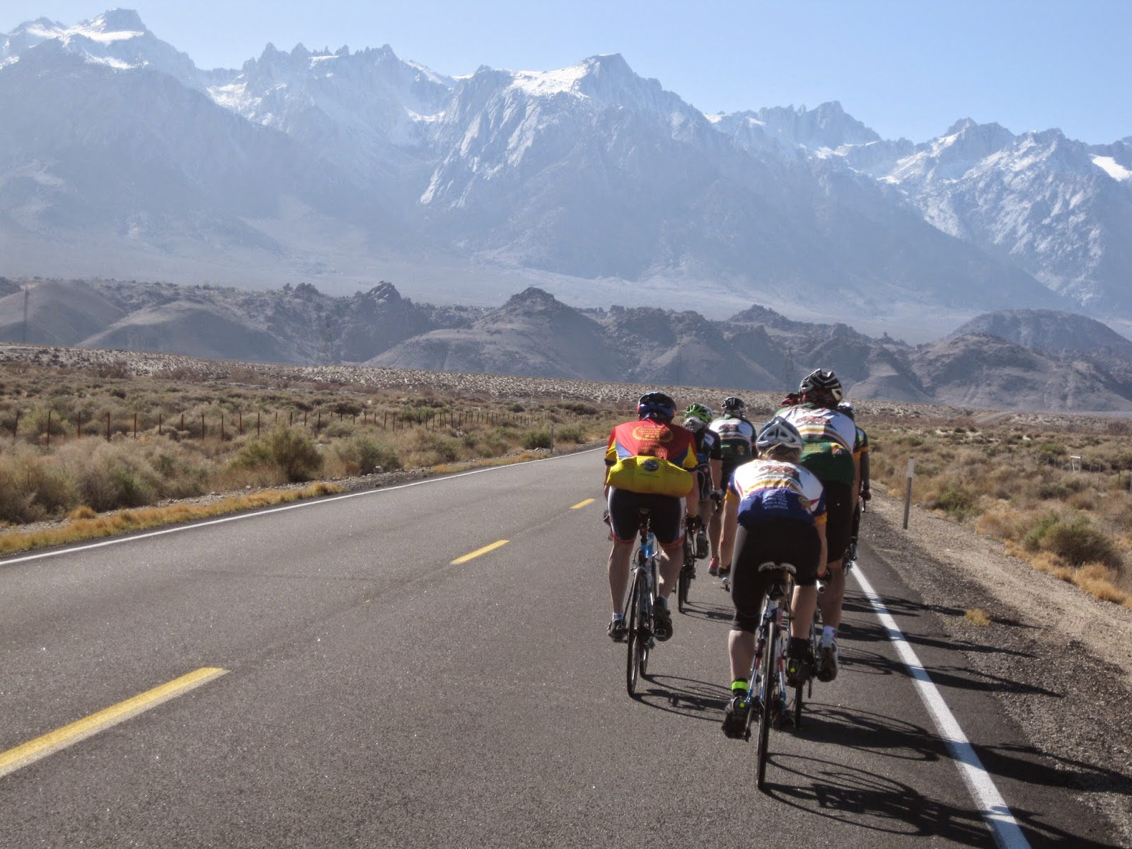
We all rolled real easy along the south side of Owens Lake from
lunch for a while before forming a pace-line and cruising pretty strong into
Lone Pine. The view of Mount Whitney and
the Sierras is spectacular on this stretch and takes your breath away.

 |
| Carrying a lot of gear |

 |
| Mount Whitney is the farthest peak in the distance. The one with the two little peaks to the left. It looks shorter due to being farther away. |
Part 6: Loop from Lone Pine up
to Horseshoe Meadows and back to Lone Pine. Mile 142
We stopped at the hotel for a second then made a left turn
on 395 again for the short southbound trip to Lubken canyon. John, myself,
Victor, Loren and Rick started the climb together but we all went up at our own
pace since we all climb different due to our weight and/or climbing
style/candence. Vic and the young stud in our group Loren flew up the hill. I
stayed a little behind Rick who is a much stronger climber than myself. He was
also getting a low tire.
We stopped at the Horseshoe Meadows turn so Rick could fix the flat, then headed south up the climb to the real foot of the Horseshoe climb one of the toughest climbs in the country.
 |
| Vic climbing up Lubken Canyon toward Mount Whitney and Horseshoe Meadows road |
 |
| Rick climbing up through the meadow with his low tire. (probably the only reason I could keep up with him) |
 |
| Fixing his flat |
 |
| Heading up to the Horseshoe area |
We stopped at the Horseshoe Meadows turn so Rick could fix the flat, then headed south up the climb to the real foot of the Horseshoe climb one of the toughest climbs in the country.
When driving on 395
and heading north, before you reach Lone Pine, for those who don’t know, it is
that zig-zagging road you see going up the side of the Sierras and it looks
insane.
 |
| We only went to the foot of this climb although it was quite a climb getting there! |
I decided after check-in at the top to keep going and not stop. I bombed down
the hill to Whitney Portal Road before dropping to Lone Pine and waiting for
everyone at the check point where we would all re-group for the last loop
around the lake.
Part 7: Final loop to the
finish around Owens Lake. Mile 198
We all re-grouped, put on our warm clothes and headed out.
It was getting chilly but not too bad just yet. The sun was just setting behind
the mountains and we knew the desert temps would drop quickly.
We cruised nice and easy around the lake for another stop at
Keeler. There was still a little light when we got there.
We all hung out for a while, had some snacks and headed back down the road for Hwy 190. The amazing smooth roads were fantastic at night. No worries about pot holes or ruts. It was great. We saw maybe one car on the 190 stretch in the dark. It was getting cold though and we were all glad we put on our things at Lone Pine.
 |
| Vic and Margaret chatting on the final loop after sunset riding away from Mount Whitney |
We all hung out for a while, had some snacks and headed back down the road for Hwy 190. The amazing smooth roads were fantastic at night. No worries about pot holes or ruts. It was great. We saw maybe one car on the 190 stretch in the dark. It was getting cold though and we were all glad we put on our things at Lone Pine.
 |
| We were visible from miles away. We maybe saw one car on Hwy 190 in the evening. |
Before reaching 395 we noticed that we were
missing some of our group. They had stopped for a break to eat some food. The
funny thing about riding at night is that you can see the lights behind you and
they look very close, but they are actually very far away. The same holds for
looking ahead in the desert on a clear night. You can see a town up ahead and
it looks real close. After what seems like forever, it doesn't look any closer.
We rolled into the final water stop across from the
restaurant in Olancha and waited for John and the rest of the group.
They all kept rolling past the stop. We saddled up and
followed. We now had a tail wind for the final 21 mile stretch on the 395 to
the finish.
It was a really nice stretch compared to those nasty head
winds we had heading into the finish last year.
A few rolling hills and some really fast stretches.
We rolled into the finish about 9pm with a large fanfare for
John.
Wow……100 doubles!!
 |
| That's a lot of events on John's back!! |
Congratulations to John Clare!
Here is the compilation video from the event:
Here is the compilation video from the event:
Here is the link to all pictures for all those not on
Facebook:
https://stephenpaul.shutterfly.com/cycling
https://stephenpaul.shutterfly.com/cycling
Here is the Garmin link to my ride stats:
https://connect.garmin.com/activity/714903840
Thanks to John and the crew at Wheel World in Woodland Hills for putting my bike together just in time for the event!
https://connect.garmin.com/activity/714903840
Thanks to John and the crew at Wheel World in Woodland Hills for putting my bike together just in time for the event!
A special thanks to Kermit and Hugh at Inyo Ultra. Thanks to all the volunteers and all the
locals who came out to support all of us.
You guys put on an amazing event and thanks for the awesome road conditions…….wow!
Thanks to Melinda Clare for the great pictures and all the goodies. Thanks to all my friends for the great pictures. Never seems like we are without good pics out there to help document the events.
You guys put on an amazing event and thanks for the awesome road conditions…….wow!
Thanks to Melinda Clare for the great pictures and all the goodies. Thanks to all my friends for the great pictures. Never seems like we are without good pics out there to help document the events.


No comments:
Post a Comment