Wednesday, June 15, 2011

The 2011 Tour of Two Forests Double Century

On this day I completed my 99th California Triple Crown Double Century. It took much more effort this year on my part to reach my goal by the Grand Tour at the end of June.

Mother Nature just made it difficult from the beginning. Most of the rides had weather challenges.
I have done 8 doubles in 2011. One of them I did not complete. The Death Valley Double was a wind nightmare. The Solvang Double was rainy and cold. We had heat come out of nowhere on Hemet. Heartbreak was a wind fest. Eastern Sierra was epically beautiful but was a real wind challenge at the end.
The rides since the end of April, the last month and a half or so, have involved a large amount of climbing. I calculated that, between the events and training, (and I didn’t train that much between), I have accumulated just under 100,000 vertical feet of elevation gained on the bike.
I am not built like a climber but I sure love it! The most beautiful of the rides involve climbing. On this event I definitely felt all the climbing I had put in my legs the two previous weekends!!

On June 11 I did one of my favorite rides. The Tour of Two Forests.
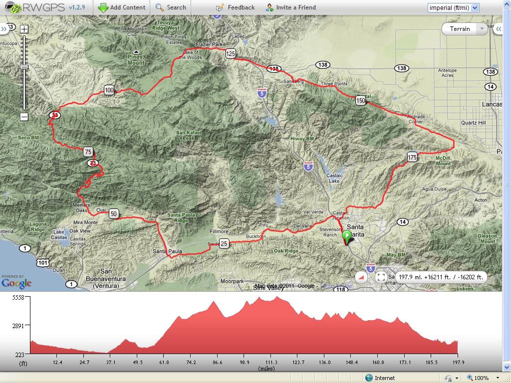


This is one of my favorites. The first time I did this event was back in the late 80’s when it started in Palmdale California. The start has since been changed to Santa Clarita, not far from home.
The event was done this year “Brevet Style”. Since there were not that many people doing the ride we just had one leap frogging support vehicle. Our support crew Jon and his sister Jennifer carried our drop bags and other goodies for us to eat and drink.
Before the event, a few of us decided we were going to start a little early and just enjoy the ride. We did not want to make it hard on the support guys by going too slow so we started early hoping that the fast people would catch us on the climb up to Pine Mountain somewhere and we would pretty much stay together from then on.

My friends Vic, Saralie, Terri and Ken started with me at around from the hotel on The Old Road in Santa Clarita.
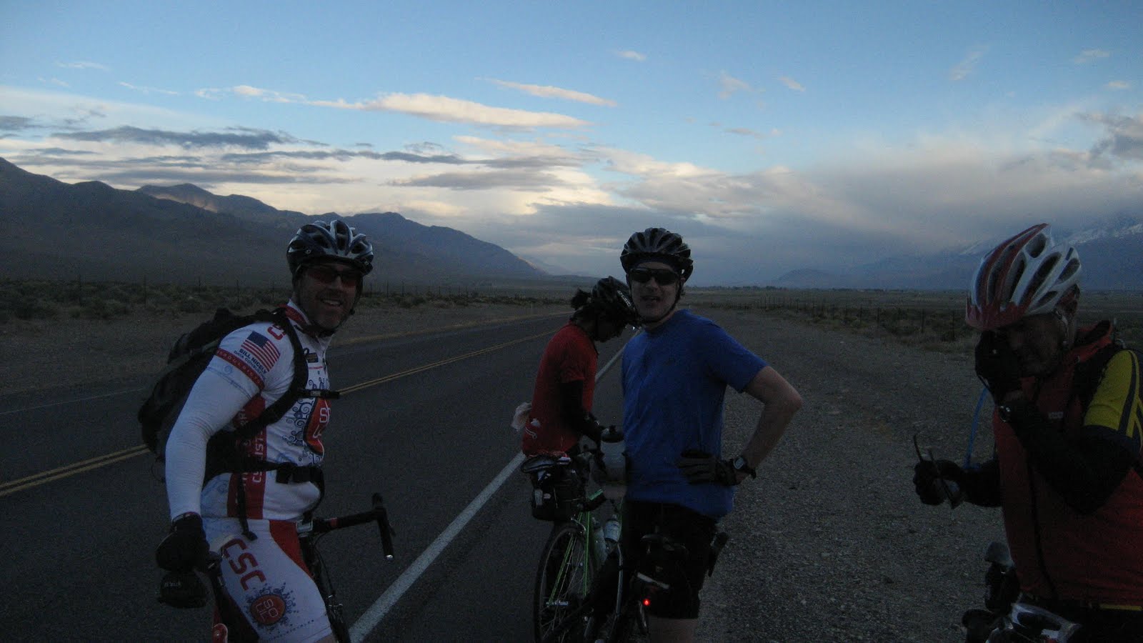
Left to right: Me, Terri, Saralie, Vic and Ken
Ken motivating down Hwy 126 at first light

We headed out of town and down the Santa Clara River Valley on Hwy 126 before turning on
Torrey Road
for a nice ride to Santa Paula through the orange orchards.

We just cruised through this first leg and enjoyed the view and good conversation. We passed Balcom Canyon on the way and joked about taking a detour up this very difficult climb which we do on the Mulholland Double. Terri almost made the turn but we talked her out of it....ha ha.....didn't need those 20% grades on this day!
Nooooo....Terri!!


Once we got to Santa Paula the climbing began. We started the climb up Dennison Grade to upper Ojai Valley.


Along the way a few miles up the road we stopped for the first check point at Steckle Park. We ate, and got water from friends Jon and Jennifer who did an awesome job supporting us.


                                          This video is us toward the top of Dennison Grade.
Upper Ojai Valley
Off we went up the climb to Upper Ojai Valley. We stopped and re-grouped at the top before rolling through the valley and then descending to Ojai down below.

Down, down we went into Ojai, a great little town just north of Ventura. A beautiful place to live!

We made a right turn on Hwy 33.

Terri up ahead starting the 30 mile climb to Pine Mountain Summit
Now the climbing really begins.

Wheeler Gorge and the climb to the summit of Pine Mountain are as epic as it gets. 30 plus miles of climbing with some of the most wonderful views. The grade averages about 4-6% so it is not too bad....just long!
This year the Sweet Broom plants where in full bloom and the whole climb smelled of their fragrance.
I stopped at the bottom to strip out of my leg warmers, vest and warmer gloves in anticipation of the long climb.


And oh what a fantastic climb it was!!

We started the climb with overcast skies, climbed into and through the clouds, popped out of the clouds for a spectacular view of the road we came up. One of my favorite.....OH....I think I already mentioned that.....it was awesome.
Jon got this pic of us talking at the Ranger Station


Along the way we regrouped at the Wheeler Ranger Station. This is where the later starters caught us. Most of us started up and stayed pretty much together all the way up to the first summit. Did I say that it was an awesome and beautiful climb? Drive this route sometime. You won’t regret it!!

Friends Rick and Tony riding with Vic in the middle

Rene', Julie and Colin climbing in the mist


The climb below...from the first summit....Matillaha...I think?  Looking toward the Channel Islands and the Pacific


I broke out of the clouds about 2/3 of the way up then went over the first summit by myself for a nice descent into the Sespe Wilderness area.

I had a nice flat to gradual climb through this area before reaching the next check point before the final climb to Pine Mountain Summit.


I relaxed at the check point for awhile, ate, had something to drink and waited for my friends to come in. They arrived and did the same. We were about 85 miles into the ride at this point. It seemed longer due to all the climbing thus far.


Pine Mountain in the distance
Off we went for about a 6 mile climb to the summit of Pine Mountain. Terri, Ken and a few others left early and were going to wait for us at the Ozena Fire Station before our next turn.

I waited at the top for Vic and Saralie, taking pics of everyone as they passed by.


Vic crank'n to the summit

Saralie cresting Pine Mountain
Bombing down off of Pine Mountain


Once they got to the top we blasted down off the mountain to meet up with the rest and the turn onto
Lockwood Valley Road
Tony on Lockwood Valley Road
Now we joined the course of the Heartbreak Double Century which I did just a couple of weeks before. We stay on the same course as that event until we almost reach Palmdale, then the course changes.
When we made our turn on Lockwood Valley road, the temps really elevated. It was now in the 90’s and there was hardly any wind to cool us.
As we slowly climbed Lockwood toward Heartbreak Hill it got hotter and hotter and steeper and steeper capping out at the summit of Heartbreak.
The temp got to about 95 with a slight tail wind that only made it feel hotter. I started to bonk some about 1/3 of the way up so I slowed up, downed lots more food, then picked up the pace some until I started feeling better. I was melting by the time I crested Heartbreak. I was not the only one!


Tony got this pic of me melting just passed the steep part of Heartbreak


Then he got me again almost to the summit
Jennifer, Vic, Rick and I chowing down
We all regrouped at the top and had a nice meal. It was about mile 100 of the ride. We still had allot of climbing to do before we were finished but it looked like we were going to have a nice tail wind most of the way back.

We left the check point for the next two climbs before dropping to Frazier Park.


The next two climbs were real nice and not too hot. Through the pines we went before our first descent into the Lockwood Valley.


First climb after Heartbreak.....Lockwood Valley here we come

Lockwood Valley with Mount Pinos in the distance
Vic and I rolled through the valley together until we reached the foot of our next climb....Owls Barn Summit. We waited for Terri, Ken and Saralie there.

They rolled in not far after us and we continued to Owls Barn. The easiest of the days climbs so far.

Over the summit we went and down to Lake of the Woods before bombing down into Lebec via Frazier Park. We now had a nice tail wind.

Ken, Vic and I turned right on Peace Valley road for the climb to Tejon summit in Gorman.

We stopped at a convenience store there for refreshment. I had a mountain dew and Vic had two plus a hamburger. I had a peanut butter and honey sandwich.
When the rest arrived we relaxed for a while then headed south-east toward Palmdale.

Ken and I chasing Saralie down on Gorman post road
Saralie and Mr. Merlin flying up the old ridge route

Vic on the old ridge route


Terri crank'n up the ridge route

Ken coming up with Quail Lake behind
We had a nice tailwind down Gorman Post road to the 138 hwy and Quail Lake area where we turned on the old ridge route.

Up....up....up we went again to our turn on
Pine Canyon Road
.
Pine canyon is one of the most beautiful roads to ride! Pines and oaks mixed, no cars, spectacular views....just epic! We all loved it and it took our minds off the grunt climbs that were along the way.


Looking back at Pine Canyon Road

After dropping down to Three Points we started a couple tough little climbs to get to Lake Hughes. On shorter rides these don’t seem bad, but at mile marker 146 or so of a double century, it hurts.
The last one was about 11% toward the top. Vic and I waited there at the top for the rest of the group. Vic just powered up that climb like a man possessed!!
Saralie did not even stop and just rolled over the summit for the bomb of a descent down to Lake Hughes and Lake Elizabeth. We all followed and had a nice mild tail wind to the next check point in Lake Elizabeth.

Vic captured this pic of the swarms we had to deal with.....wow
Getting hit by B-29 sized bugs on the way down and along the lakes we made it to the check point.
There were gigantic swarms of mosquitoes everywhere and they were not biting. Just swarming. Weird! Vic got a great shot of the possessed bugs.
We got all our lights set up, put on our cold weather gear and headed out for the last climb. Bouquet Canyon.
We were flying with a tailwind toward Palmdale before we got to our turn. We made the turn with still some light left and started the climb. We could see fog coming over the mountains and thought we were going to be damp and cold on the way back down to Santa Clarita.

Up we went and then we heard them.....coyotes...coyotes!! Were they stalking us? Could they smell our sweat and all the carbs we had been eating all day?  Were we to be there dinner?

We were joking with Saralie about it and howling ourselves when she thought she might have a flat tire. It was making a funny sound. It was a flat and just part of doing one of these events. It happens and you can’t get upset about it. Just fix it and move on.
Saralie and I working on the tire while Vic and Ken hold the coyotes at bay
She took her bad tube out and began checking the tire for foreign objects. I checked it and didn’t feel anything with my gloves. I thought I would snag it if there was something in there. She checked one last time before putting a new tube in and good thin she did.
She found a small piece of wire. So small that you could hardly feel it. We could not get it out. It became kind of frustrating until Ken found a pair of tweezers. Ken saved the day. We got it out, pumped up the tire and were on our way.


After the summit we had a long descent back to Santa Clarita and
Copper Hill Road. In the dark it just seemed to take forever.

We made the turn at the bottom, had a couple more climbs before reaching the
Old Road near Magic Mountain. Left we turned for a long gradual climb past Magic Mountain and the finish.

An epic day to say the least. We finished late but never really pushed ourselves to our limits. We just had a great time. All of us.

A great thank you goes out to Vic, Saralie, Ken and Terri. I had a great time and loved sharing this event with them.




Tuesday, June 7, 2011

2011 Eastern Sierra Double Century


This has to be the most beautiful of cycling events! The High Sierra Mountains of California are natures playground for many. Epic Alp-like views and diverse climate changes make it just an amazing event.


This year it was just beautiful as usual although somewhat challenging at the end.

I had some business to do for work Friday in the morning so I did that on my way out of town. The weather was nice but the forecast was for some pretty inclement weather up in the Sierra's. I was hoping for the best as I drove north up the Owens Valley. I had a strong tailwind blowing me in my car all the way so I was somewhat nervous about the event. Nothing new!! All the events this year have been challenging due to weather. Mother nature is really making my century quest hard this year!!

I stopped along the way to see my old friend Hugh Murphy whom I have known for years. I first met him while doing his events back in the early 90's. My Wife, Kids and Sister in law used to work the events while my brother in law Vince and I did them on the tandem. We did all the Doubles on the tandem back then. Even before the Triple Crown came about.
I will never forget Hugh sitting in the back of the support van with his legs dangling, at 50+ mph, taking pictures of Vince and I descending off Jubilee Pass on the tandem at breakneck speed on one of the Death Valley Events.
Hugh let me try his trike

I reached Bishop, Ca. at about 5pm and the winds were just howling out of the south.
I checked in at Browns Town Campground and got my van ready for my night. Then I got my bike and gear all ready.
I went and checked in for the mornings event, got some dinner, headed back to the camp, set my alarm for 3:30am, then hit the sack early at 8pm. The wind let up quite a bit at night so I was not too worried.

A couple of cups of coffee in the morning and I was ready to go. The wind was not too bad when I arose.

I drove over to the start, talked awhile with some friends and waited around for the official start at 5am. We watched as a few people started early.


It was a fantastic morning as we started the event. First light in this area is just spectacular. Especially out in the open air riding in it.

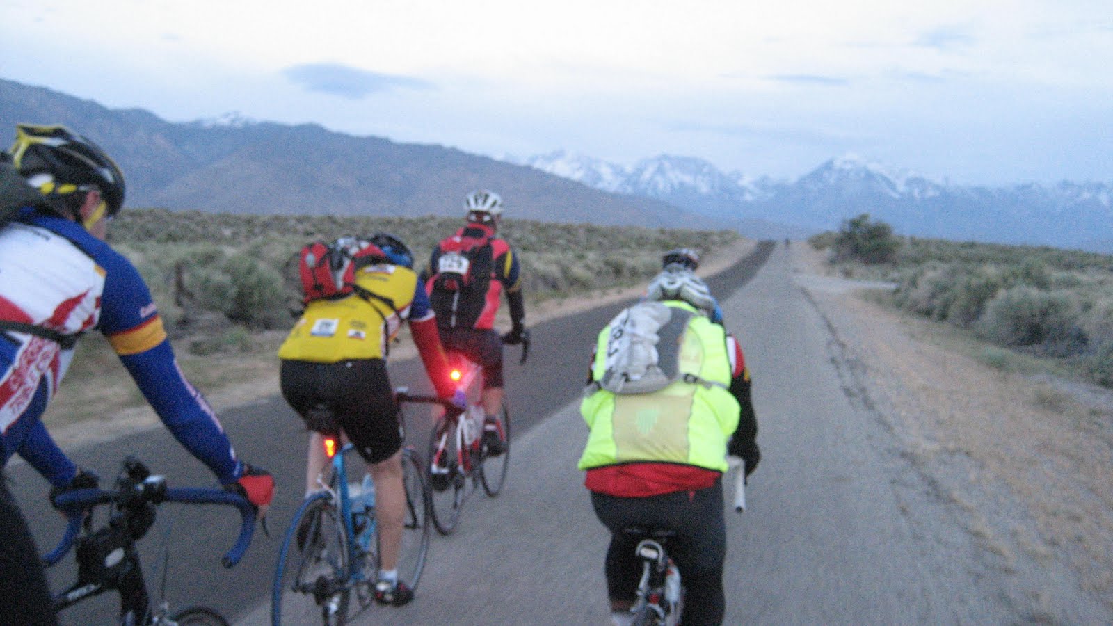
Chuck Bramwell on the left

We headed out of Bishop in a clockwise loop to the East on East Line Street before turning South then West on Warm Springs Road. We then crossed Hwy 395 and headed North toward Round Valley to the North-West of Bishop. I rode this first section with my friend Chuck Bramwell, (the Triple Crown Guy). He is the founder and runs the California Triple Crown Double Century Series. We were in a good size group and had a nice tail wind once we headed North.


The weather forecast was for snow showers up in Mammoth Lakes and June Lake where we were headed so we all were really weighted down with extra cloths and gear. I must have had 5 extra pounds of stuff with me just in case. (you can always strip but if its cold and you don't have enough gear, you are done for the day.)

I had plenty of food and water for over 50 miles, the climbing to come, was totally in a good, "zone", so I opted to skip check point one at Round Valley School.

Onward I trekked toward the first and one of the longest climbs of the day, Old Sherwin Grade. I love this climb!! You feel like you are in the Alps as you climb against the backdrop of the  looming Sierras.

Sherwin Grade in the distance

For those who are familiar with the area, Sherwin Grade is the long climb as you drive from Bishop, North to Mammoth Lakes. You get to the summit of the grade when you are around Crowley Lake area.

We climbed that grade on the old road to the West of Hwy 395.

On the way up we went through one of my favorite little communities, Paradise. This area has one of the best views of the Sierra's. It is an artsy place. Some people display their artwork in their front yards.


Artwork on someones lawn...Paradise.


Just past Paradise
 

2/3 of the way to the summit of Sherwin...looking south-west

I felt fantastic as we reached the summit of the grade at mile marker 39.6. Then we had a little more climbing through Lower Rock Creek before we made a left turn on Hwy 395 North.

We stayed on 395 with hardly any traffic until we made our left turn and headed up Crowley Lake Drive to Check Point #2 at Crowley Lake Park.
I stopped for water and stocked up on more food. My plan on this ride was to stay in my comfort zone so I would not have to stop again until lunch at mile 104.5.

Hwy 395 to the right in the distance


Off we went paralleling 395 until we turned on to it at mile 52.3.

Now it was onward on the Hwy for about 6 miles into the Mammoth Lakes area.


Check the wind sock....wheeew...tailwind
Our old Cessna 402 on another trip to Crescent City
We passed right by the Mammoth/Yosemite Airport along the way. I have great memories of landing at that airport in my Dads Cessna 402 for ski trips.
I will never forget buzzing the mountain once on a nice clear day while flying up for some skiing.
Oh the great adventures we had with Dad in his planes!!
That is a really tricky airport to come into if you don't know what you are doing. The runway is on a hill and is not totally flat. While taking off or landing, it looks like you are running out of runway but you actually have more runway over the horizon. There is also a small mountain on the South-East end of the runway so it can be real tricky in IFR or poor visibility conditions. Not for the faint at heart!
Past the airport we went. I noticed the wind sock was pegged to the North with the tailwind I had to my rear. This made this first stage of the ride nice but did not look good for the finish into Bishop because the winds usually intensify in the afternoon up the valley floor.

Mammoth Mountain
At mile marker 59 or so we made a left turn for a 4 mile climb into Mammoth.
Now the altitude really kicked in. I was somewhat used to some higher altitude from doing Heartbreak the prior weekend but those summits were around 6,000 feet. We now had three summits to do over 8,000 feet and I was feeling it!


I made the climb up to Minaret Road in Mammoth feeling somewhat light headed. I knew it was just the altitude but it really slowed me down. Down into the granny gear I went and I just spun my way up. We went one mile on Minaret and them made the turn on to The Mammoth Scenic Loop at mile 64.


Up we went into the snow zone to the summit on the scenic loop. Then came the reward. The road was newly paved and just wonderful for the 48mph descent down to Hwy 395. It was cold though. Glad I was prepared. No storms yet as predicted.


I turned left on the highway, rode a little under 2 miles, then waved at the guys at Crest view Rest Area. I was happy as I went by feeling really good, still with plenty of food and water.

Deadmans summit ahead
Now came the second 8,000 ft. plus summit. DEADMAN SUMMIT. It is about a 3.5 mile climb. Not too steep but the altitude makes it feel worse than it is. Only about 4-5% grade but it felt like 9% at times with the lack of oxygen.


I stopped at the summit and took a few pictures. The smell of the pine tree is amazing up there!

Down, down now I dropped to my next turn 3.9 miles down the hwy....The June Lake Loop...one of the most spectacular places to ride or vacation.

The June Lake Loop is a 15 mile loop that takes you around 3 lakes at the foot of the Sierra's before you come back out on the other side by Mono Lake and Hwy 395.
Here are some pictures on the loop.

Taken by one of the SAG drivers. Whats wrong with this picture? ITS JUNE!!!


Getting rained on here for the first and only time

We turned left on 395 at mile marker 94.4 for 10 miles to our lunch in the Lee Vining area of Mono Lake. We passed the turn-off for Yosemite and Tioga Pass and it said it was still closed. I was told it most likely wont open until August due to all the snow this year. Amazing!!!

Terri and Tony at lunch....Mono Lake
I saw my friend Terri there. She was staffing the lunch stop.

I gobbled down a subway sandwich, had a coke, used the facilities and then hit the road with a couple of guys I met on the last leg to lunch. Brian from Fresno and Brad from San Luis Obispo. Both strong riders and both doing the Eastern Sierra for the first time.
Mono Lake after lunch

We now had to head Southbound on 395 which meant we would find out finally what the winds were going to be like of the return trip to Bishop.

Southbound we went on 395 to our turn on Hwy 120 ten miles down the road. We had about a 20 mph headwind but not too bad. (yet)

We made a left turn on hwy 120 for the long trudge to the second highest point on the ride....Sage Hen Summit 8,139 ft.
Brian climbing Sage Hen
It seemed to take forever to get there on this stretch. Lots of steep rolling sections of about 10% as it kept kicking up. We saw the highway patrol many times out there and hardly any other cars. I think they were out there just to try and catch one of us doing something.


Brad climbing Sage Hen


It was nice and cool for a change on this climb as we made it to the summit through the pine trees. A nice cool breeze from the south. In years past it was blazing hot on this section with no wind at all.


Brad and Brian reaching the top
Brad, Brian and I made it to the top together, stopped to fuel up and headed out.

The wind at the top was fairly calm. I thought it would be howling up there because the forecast was for winds gusting to 60mph in the mountains of the area. I was excited.


We now had close to a 3000 foot descent and some 30 miles with some small climbs, (some tough), in between before we made it to Hwy 6 in Benton Springs.
Heading toward Benton

As we started the descent the winds were nice and calm and we were cheering!

We came around one bend and BOOM!! We got hit by maybe some 40mph crosswind gusts that dropped our speed from 39mph down to 15 almost instantly, (on a steep descent). Now we were pedaling hard on the descent and working out butts off when we thought we would finally get a reward after that long climb. We really had to fight our way down off this summit. We could see large dust storms in the distance toward the direction of Benton. We knew at that point we were in for it big time on the return from Benton to Bishop.
The head/cross winds on this stretch before the last climb into Benton were not the only problem.
We all thought we were going to break out bikes on the large ruts in the road. This section has always been notorious for these 5+" wide ruts in the road. As long as I have done this ride they have been there and they don't fix them. Even on one of the new paved sections where they paved over them, they are coming back in the same places. I think the old road on this area must have been concrete, separated at the expansion joints and they just paved over it. No way to fix that unless they tear the whole thing out and start new. That is the only thing I can think is happening.

I started to feel a little low on energy and thought I was going to bonk so I let Brian and Brad go ahead while I pumped down some food and slowed down some. I just paced myself over the bumps and into the wind as I climbed and cursed those hills in the middle of the descent. Small ones, seemed steeper into a strong headwind and no relief on the descent having to pedal down the hills instead of resting. ARGGG!!


I finally made it to the final climb before the descent to Benton. I could see Brad and Brian climbing the hill up toward the top.
I hammered up, hoping that I could catch them on the downhill. It is a fast descent into Benton!!


I had some strong cross winds right at the start of the descent then I turned north some and was just flying at close to 50mph with a tailwind.


The descent to Benton. All that haze is dust!! Brad up ahead
 I should have just relaxed instead of trying to catch those guys because when I made a right turn for the final little drop to Benton I got hit with a crosswind that almost blew me off the road. Good thing I have fast reactions.
I slowed down some then I saw Brad up ahead just almost stopped. He was just burnt out with only about a mile to got to Benton. The SAG car came by and he stopped him. I thought he was going to call it quits with only 37 miles left. He was just asking the driver where the checkpoint was.
We both rolled in to the check point in Benton at a little after 5pm I think. The wind was howling and getting stronger.

We fueled up and rested for a little while. Myself, Brad, Brian, a guy named Gustavo from Davis, and another rider John all decided to team up and finish the ride together into the wind. We were all going to take no more than 1 minute pulls at the front of the line then drop back to the rear. This way we could get back much faster than if we rode alone with no drafting effect.

The last 36 miles took over 3 hours and it was a mind altering experience.
The last time I did this ride in 2009 I had a tail wind on this last section and it took me slightly over one hour as I got blown back to Bishop.

Here is a video that gives a small idea of the wind conditions we faced.
Children do not try this at home. Professional driver on a closed course. (trying to take a video while trying to hold the draft in a pace line.....nuts I know!!)


Rest #1 for a breather

Rest #2

Left to right. Gustavo, Brian, Brad, Me and John.
We only averaged about 10mph with a group of 5 riders on that last section. The winds were gusting in such a way that it kept trying to blow us out of the line so we would lose the draft and have to sprint back in line.
In the end we all worked together as a team and we made it back just slightly before dark.

Start time: 5am
Finish time: Sometime around 8pm.
Time on bike; 14:16
Overall time: 15:18
Altitude gain: From my VDO computer: 10,610 ft
Average climb: 3%
Maximum climb: 13%
Results: http://www.planetultra.com/easternsierra/Results/2011%20results.htm
All the Pictures can be seen at: www.stephenpaul.shutterfly.com/cycling

Summer and Fall 2025

  After getting through my back surgery ordeal and finally doing my 200th double century back in June, I decided to round out the year with ...