A short prelude:
“The most
epic and challenging ultra-cycling race, the Hoodoo 500 route passes through or
around three National Parks, three National Monuments and several Utah State
Parks. The scenery varies from majestic cliffs and striking red rock hoodoos to
aspen and pine forests and high mountain meadows. All the best of Utah
Geologically speaking, hoodoos are tall,
skinny spires of rock that protrude from the bottom of arid basins and
sedimentary rock.
Mystically speaking, hoodoo means a magical
spell; which is what the Hoodoo 500 experience will cast upon you.”
I totally agree with what it says above about this
experience casting a spell on you.
After doing the event for the first time last year as a 60+
division solo racer with a crew I just had to do it again and I made the
decision when I finished the race.
It was one tough race to do solo at my age but the “Magical spell”
was cast upon me.
I don’t know what came over me at the beginning of 2015 but something
in my head said I should attempt to do it in the Voyager Division this time. I
ALWAYS train on my longer training rides carrying a camel-bac hydration system
and two bottles along with everything I need to stop as little as possible.
I was thinking “this is how I train all the time anyway”, so why not
try an ultra event in the same fashion. Little did I know what I was getting
myself into at my age?
After almost a full year of doing ultra events and training
for this, the day was upon me.
Again this year I was riding to bring awareness to The House Clinic in Los Angeles and Neural Tumor Research. The doctors and staff at The House Clinic saved my life and I will be always indebted to them.
All my friends told me I was going to do great and I felt great physically. The only thing I prayed about a lot was a mechanical problem. My bike is pretty old and I am not much of a mechanic so I figured since I have to be fully self-supported, if something was to happen other that minor adjustments, I might have a problem finishing.
Again this year I was riding to bring awareness to The House Clinic in Los Angeles and Neural Tumor Research. The doctors and staff at The House Clinic saved my life and I will be always indebted to them.
All my friends told me I was going to do great and I felt great physically. The only thing I prayed about a lot was a mechanical problem. My bike is pretty old and I am not much of a mechanic so I figured since I have to be fully self-supported, if something was to happen other that minor adjustments, I might have a problem finishing.
I arrived in the start city of Saint George , Utah on the Thursday
prior to the race and helped with rider check-in for the Hoodoo Stage Race
which was to start on Friday morning. I had some friends doing that division
too so I had a great time taking their pictures when they checked-in.
The course:

 |
| Full elevation profile |
A little note about the Voyager division from Planet
Ultra:
“As a Voyager Racer
you’re required to be completely self-sufficient, fending for yourself along
the way, and carrying much of what you need for the duration of the race. The
Voyager division is not intended to be, nor is it, simply racing without a
crew. This is an extreme race and a test of far more than cycling ability.
While perhaps not as difficult as Hoodoo, the inspiration for the Voyager
division is races such as the Iditarod and Trans Rockies .
You’ll be testing yourself against the elements, the road, and all the
circumstances that may arise during this long and challenging race. The Voyager
Division is intended to be somewhat like an unsupported brevet, but even
tougher. There is absolutely no support provided other than the drop bags and
water at manned checkpoints. While there are many places along the route to
obtain food, water and lodging if need be, there are also long, difficult
climbs and descents without any services and the potential for extreme
weather.”
“We can’t emphasize
enough the need for carrying an insulating layer in addition to your jacket,
especially over Boulder
Mountain Boulder
Mountain
The Event
 |
| My mug shot |
 |
| The voyager group |
The Voyager division starts at 5 am with the solos rolling at 7 am and then the teams a while after them. Solos and teams
have a 48 hour time limit. We got a couple extra hours to complete the course
due to the extreme nature of doing it self-supported. All racers must be
finished by 7 am on Monday
morning.
We rolled out of the gate on time. I had two friends with me
in the Voyager division. Rick Jacobson is a legend in this division having done
it many times. Brook Henderson is a young kid who did the 500 mile solo
division last year and the 300 mile “Nomad” division (same as voyager but
different distance), a couple year ago. He is a fast beast!
The first part was a neutral section till we got out of town and the traffic lights. We just cruised at an easy pace until we reached the point where the actual race starts, Washington Dam Road.
Part one: Saint George to Kanab 0-86.6 mile
 |
| Elevation profile for part one |
 |
| Voyagers on the line and ready to go |
 |
| Heading out of town |
I was following Rick and not paying enough attention to my route when I missed
the first turn and ended up on a gravel road in the dark. It did say on the
route slip that it was easy to miss……my Garmin yelped at me because it saw I
was off course. We went back and found the turn. Really easy to miss in the
dark!
We rolled through the town of Hurricane as it was starting
to get light before turning on Hwy 59 at mile marker 26. Now we had the long
climb out of the dam area. I just rode at my own pace and let Rick go after we caught up with everyone else except Brook and one other. That other guy came all the way from Connecticut. His name was John Nobile and he ended up winning the Voyager division. Amazing.
I now had 54 miles before the next turn in Fredonia Arizona.
The climb up out of the basin was beautiful as the sun came up. Once I got at
the top it was one of those long open roads all the way to the next turn. I just got in the aero bars and cruised at a very easy pace although my heart-rate was a little high. (I think it might have been the double shot coffee I had before starting!!)
 |
| Climbing out of the dam basin |
 |
| Sunrise on the road to Fredonia |
I could see Rick up ahead the whole time in the distance and
then I lost him just before Fredonia. I guessed because he had made the turn.
 |
| The long road ahead |
I just cruised in my aero bars whenever I could and spun the pedals. I was not riding this like a race. I was just out training. (that's what I was thinking in my head of course)
This section was probably the longest straight road of the race. It was such a beautiful section. I knew it was only going to get nicer as we moved back into Utah.

I rolled into Time Station One about 10:46 am and Rick was not there. He got there a few minutes later and said he had stopped for water. Another voyager, Roger from Tucson came in a little after us.
This section was probably the longest straight road of the race. It was such a beautiful section. I knew it was only going to get nicer as we moved back into Utah.
 |
| Hello Arizona |

 |
| Leaving Arizona |
I rolled into Time Station One about 10:46 am and Rick was not there. He got there a few minutes later and said he had stopped for water. Another voyager, Roger from Tucson came in a little after us.
 |
| The two Jennifers manning Time Station one |
 |
| Rick and Roger |
I went into the store and grabbed a Pepsi and took a break. It was so refreshing.
Part 2: Kanab to
Bryce 86.6
– 158 miles
 |
| Elevation profile for part 2. |
It was already getting quite hot.
I rolled out of the check point feeling really
good. As I rode into the town of Kanab I came across a western wagon train
heading into town on the road. I had time warped back into the old west!! They
were getting ready for a big parade in town when I rolled through. It was
great!
It was kind of funny because there was a big bus behind the wagon and I couldn't help but think that these were two bus's, one from old and one from the new age. (at least I thought it was funny.)
It was kind of funny because there was a big bus behind the wagon and I couldn't help but think that these were two bus's, one from old and one from the new age. (at least I thought it was funny.)
 |
| Old tour bus....new tour bus |

This next section encompasses some good climbing up to a
summit near the entrance to Zion National Park. The area is called
Mount Carmel Junction.
 |
| Its getting hot..about 98 degrees on the road |
The field was already
stretching out in the heat and wind in this section. I went through over 150
oz. of water getting to that summit. I was glad I came across the vehicle rest
stop about half way so I could fill up with water. I saw my friend and race
staffer Tony on the road in this section. He was on his way to man the Loa Utah
checkpoint. I hoped to be there in the wee hours of the morning.

 |
| Cruising up Hwy 89 Photo by Tony Musorafite |
 |
| What a beautiful place! |
During this climb, the first of the solo riders caught up
with us. One guy looked like a pro as he passed me like I was standing still. I found out that he DNF'd at the second time station due to stomach problems. The second guy, Mark Scarpohl, I knew. He is from Minnesota. He also looked
like a pro. He gave me a holler as he passed. Really nice guy. He ended up winning the entire race and setting the 50+ solo record!!
 |
| Mark Scarpohl |
Rick is a very good climber and caught up to me. He passed
saying he would stop at the store on the summit. I rolled in right behind him
with an upset stomach and I was getting worried.
I was prepared for the stomach problem. I dropped two
alka-seltzers in my water bottle and started sipping it while resting there
with Rick and Roger. It did the trick and I felt like a new man!!
While resting at the store we saw 6 time Race across America
winner Seana Hogan go by. She was attempting to break her own course
record. An amazing cyclist. She ended up getting second overall and breaking her own 50+ record. Amazing!!
On all the climbs
thus far, I felt like I was riding my tandem bike. I could really feel the
extra weight I was carrying for this division. I knew I had to just stay steady
and I would be OK.
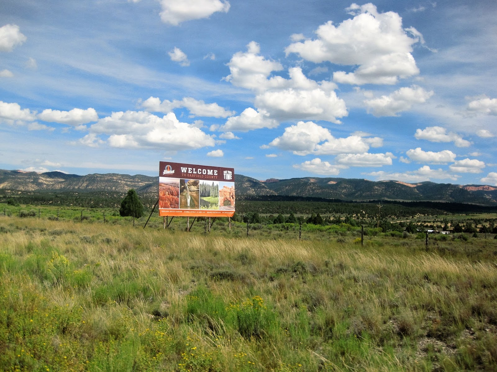
Onward I went for a nice descent and rolling section to my
turn on Hwy 12. The scenery was getting better and better.
 |
| Almost to the turn |
After flying through this section, I turned on Hwy 12.
Hwy 12 is considered one of the most beautiful thoroughfares
in the world. It is spectacular to say the least. It will take us all the way
through Bryce, Escalante-Grand Staircase, Boulder and over Boulder Mountain to
Torrey Utah before we turn.
 |
Approaching Red Canyon
Up I went on Hwy 12 for a couple miles until I entered “Red Canyon”. Wow what a beautiful place. Pictures just don’t do it justice. Through this section for about 7 miles we are required to ride on the Red Canyon bike path. It is illegal for bikes to ride on this section of the hwy. The path was spectacular.
|
 |
| Heading up the bike trail |
 |
| RAAM veteran Dave Elsberry |


I had a number of solo racers and teams pass me along this
section. This is where I had anticipated that this would happen based on last year’s
solo effort when I was catching the Voyager riders while riding solo.
 |
| Maria Parker approaching on her recumbent bike |
 |
| Maria Parker |
Part 3: Bryce to
Escalante 158
– 207.4 miles
 |
| Part 3 elevation profile......(look at that descent would ya!!) |
Now came….for me…the most spectacular part, the ride into
Escalante. Leaving Red Canyon and now into something completely different.
Majestic cliffs, spires and canyons.
Leaving Bryce we started with an amazing, almost, nine mile
descent into the town of Tropic.
Finally……a descent with some substance to give me a break
carrying all this extra weight.
It was relatively flat rolling through Tropic before I
started to climb again toward Escalante. I got plenty of pictures in this
section of the course. It was beautiful but kept slowly kicking up in elevation
gain until the final kicker before a long descent into the town of Escalante.

 |
| WOW....I would love to live here! |

 |
| A beautiful section of the course Photo by John Clare |
 |
| Playing with the camera a bit |


I approached the final kicker to the summit and saw my friend Jon Shellenbarger's crew stopped up ahead again. I stopped for a second to take a short break so I
took a picture of the climb.
 |
| One beast of a little 12% kicker climb. Jon's crew up ahead |
This is one tough puppy but luckily fairly short. It has a
gradient that slowly increases to about 12-13% at the top. For the first time
on the event I used my really low gears and just spun the climb up. It actually
seemed easier than last year…..go figure….and I was carrying everything but the
kitchen sink!
 |
| Curtis and Ed cheering me on at the summit |
I rolled over the summit and started the amazing and
beautiful descent to Escalante at sunset. It’s a long and cold descent and I
started to get a chill. I saw Jon and his crew up ahead so I stopped just ahead
of them. Jon was putting on his cold gear.
I asked Ed if I could lean my bike against his truck. I am
still laughing at his comment and I quote. “I
will have to report it as offering assistance to a Voyager racer”. My
fellow Adobo Velo club brother and endurance director of the club was joking of
course. A voyager can get a time penalty if he accepts assistance of
any kind during the race.
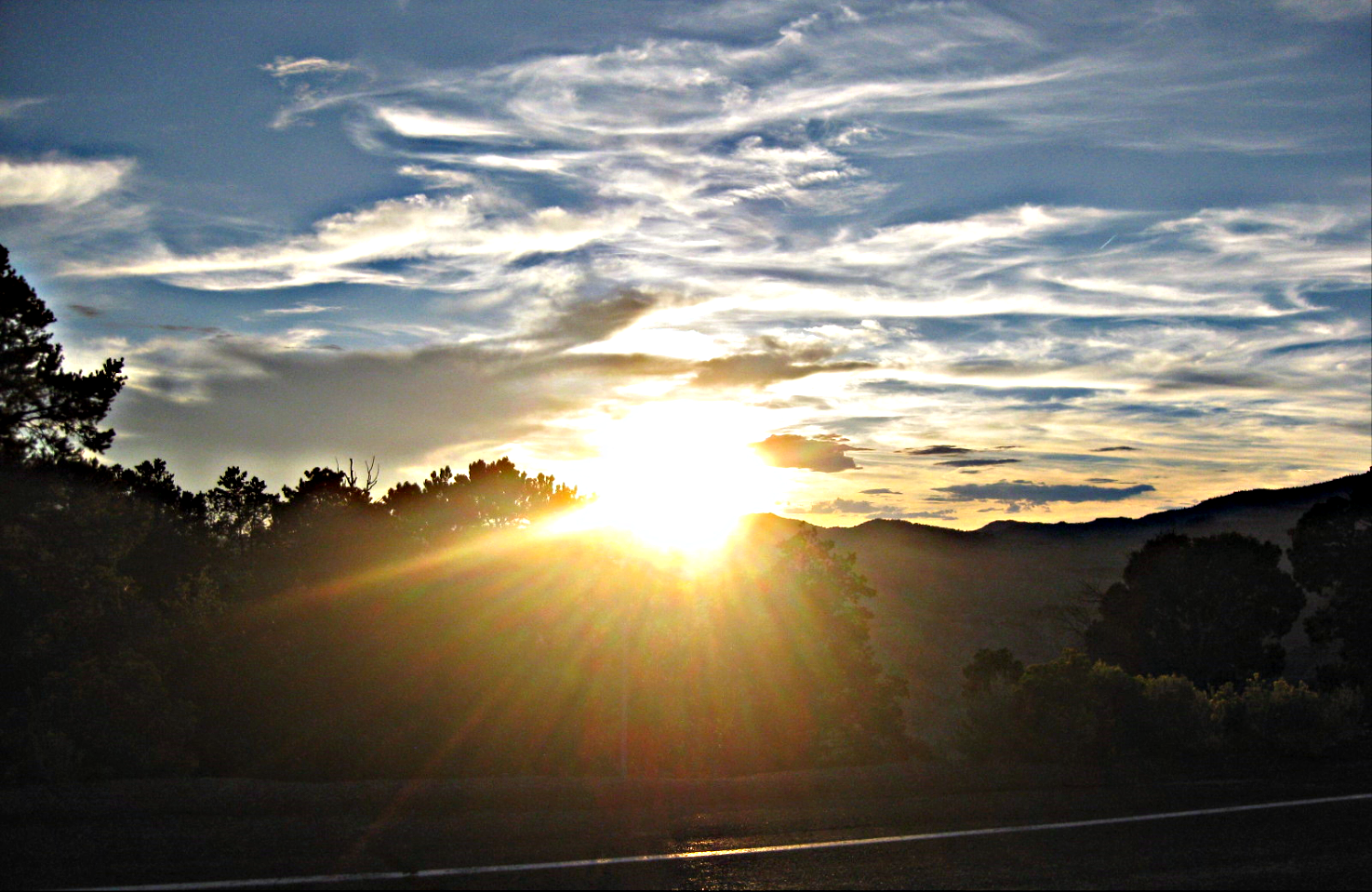 |
| Beautiful sunset descending into Escalante and into the first night of the race |
I put on my wind breaker and bombed down into Escalante and
time station 3.
Part 4: Escalante to
Loa, Utah 207.4
– 288.7 miles
 |
| Elevation profile. Boulder Mountain |
They say the race does
not start until Escalante and they are right. From here on in, this is where it
all can hit the fan.
 |
| Race director Brian Bowling in Escalante |
I put on my knee warmers and my “Showers Pass” wool base
layer. I packed my heavier rain jacket….also “Showers Pass”. These are arguably
the best inclement weather gear made in the US. The company is in the
north-west where it rains and snows a lot. I also packed my heavier gloves just
in case.
I rolled out of town a little after 9pm with a giant “super
moon” right in my face. It was spectacular.
I slowly cruised up over a couple of rollers. I had a couple
more fast 4 person teams pass me in this section as well as my friend Judy Brusslan who
was being supported by her daughter and husband. Judy is a strong climber and
can drop most anybody on a climb. She was doing the solo 500 race.
Last year we did not have a moon at all and it was pitch
black on both nights of the event. This year we had a super moon occurring. You
could see everything like it was dim daylight!! Just amazing!!
I dropped steeply into a deep canyon which I didn’t even see
last year.
Reaching the bottom there was a river rushing and it was really loud.
The canyon around me was glowing orange and was so spectacular that I was
tempted to get off the bike and just take in the splendor.
This year I could see that I was in a very deep hole with
cliffs surrounding me.
This area of the “Grand Staircase” is just amazing.
The Grand Staircase refers to an immense sequence of sedimentary rock layers that stretch south from Bryce Canyon National Park through ZionNational Park and into the Grand Canyon.
Its just amazing.
Its just amazing.
Now came one tough climb! I had to climb out of this canyon
up onto the infamous “Hogs back”. The
hogs back is a road with sheer cliff drop offs on both sides.
The climb out of the canyon has grades of 14% and zig-zags
up the canyon sides.
As I looked up I could see other racers and there follow
crew vehicles slowly crawling up the climb. It was a majestic sight, seeing the
canyon and the flashing amber and red lights way up the cliff wall very slowly
climbing. ( I just wish I could have caught that on video)
I slowly made my way up to the ridge and looked down on both
sides. It was again amazing in the moonlight.
I now descended into the town of Boulder where I stopped at
a closed gas station. I got a Pepsi out of a coke machine. I wolfed down some
food for the climb to come…..a very long and possibly frigid one.
Now for the next challenge……Boulder mountain….9,600 feet in
elevation…..a steady…long….unforgiving climb with no level breaks to speak of
before the summit.
The climb is about 16 or so miles long with 3,200 feet of
gain and with about 236 miles in your legs and almost 14,000 feet of elevation
gain in the legs, it’s a tough one.
I took it easy and kept my training pace up the climb using
my low gears. I saw lights coming up behind me very slowly. I thought it might
be fellow voyager Rick. It turned out it was my friend Jon. He slowly came up
behind me and we rode for a little while before I let him go ahead. He was
having bad stomach problems and not feeling well at all. I would see him one
more time as I passed he and his crew at the side of the road. This would be
the last time I would see Jon.
I passed all types of wildlife on the way up. Deer, fox,
owls and many cows grazing on the mountain standing right in the road.
 |
| Boulder Mountain Summit.....wooohooo!!! |
I rolled over in the moonlight and started the very long
descent to Torrey.
When I got to Torrey I saw my friend Dave Elsberry’s crew
van parked in a parking lot. I figured he was taking a sleep break.
I now had, what seemed like forever, 17 miles to the next
check point in Loa….and I had a cold head-wind!! It seemed to take forever but
I made it in not long after the time I did last year. A little after 4am.
I checked in with my
friend Tony who was manning the checkpoint with his friend Ellen.
He said there were
still 20 solo riders behind me which was quite a bit of the field. He said that
Rick was still up on Boulder Mountain somewhere and that Judy had stopped to
sleep on the mountain somewhere. Dave was, as I thought, sleeping in Torrey.
Part 4: Loa to
Panguitch, Utah 288.7 – 379
miles
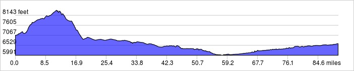 |
| Elevation profile
It was cold leaving Loa like last year. Right out of town I
started an endless “stair-step” climb with many many false summits to the real
summit at about 8,300 feet. You can see them on the profile!
Elevation gain from Loa about 1,300 feet in about
14 miles or so.
|
The sunrise was spectacular as I summit-ed out of Loa. I had
the super moon in front of me and the sun just getting ready to rise behind me.
 |
| Almost to the summit above Loa at sunrise |
 |
| Riding at sunrise into a setting super moon toward Koosharem, Utah |
 |
| Rolling over the top |
There I connected with Utah Hwy 62 and started heading
South-bound.
This leg is traditionally known for head winds. I was fairly
lucky last year with mild headwinds. I had good conditions thus far on the 62
as I rolled along on which would become the very toughest leg of the course for everyone. I
stopped for a little breakfast break along the way before my next turn.
 |
| Koosharem, Utah |
 |
| Just me and my bike. Time for breakfast! |
I made the right turn toward the west and Panguitch on Hwy
62 west. Now the winds slowly started as I rolled through the beautiful hills.
 |
| Heading down 62 West toward Panguitch. The winds begin! |
I reached the little town of Circleville where I had a flat
last year.
Now the winds started violently as I rolled uphill and out
of town into a small canyon.
The winds increased exponentially as I moved toward
Panguitch to a point where I could only make 8-10 mph on a flat road. I almost
got blown off the road a few times but I did not want to stop. (you just have
to keep moving forward they say and you will get there…right? )
It took me over an hour to make the final 10 miles to Time
Station 5 and I was spent.
I took about a 30
minute break in Panguitch but couldn’t sleep. Fellow voyager Karen Dee Williams from Salt
Lake was in the voyager room resting when I arrived. We both talked a little. I
had met Karen at rider check-in. A really nice young lady and very strong
cyclist.
Karen rolled out not
long after I got there and I rested a little bit longer.
Part 5: Panguitch, over Cedar Breaks, to Cedar City,
Utah 379 – 437.4 miles

This is the longest
climb of the event. From Panguitch you
climb to Cedar Breaks at 10,600 feet. The climb is 31.7 miles or so with 4,000
feet of elevation gain.
This is a deceiving and mind altering climb
though. The road kicks up right out of town for a little bit then mellows for a
while until you reach Panguitch Lake. From then on it seems never ending with
less and less oxygen. A 3% grade literally feels like a 15% grade when you get
above the 9,000 foot level with 400+ miles in your legs and carrying all the
extra weight.
I was feeling terrible when I left the time station so I
stopped at the store across the street and grabbed a Cherry Coke. Wow that was
good!!
For the first time during the race I started questioning my
sanity and why I was doing this. I felt totally waisted and was worried about
finishing.
I finished my coke and started the climb out of town. About
halfway up I started feeling better. The clouds had come in and I was climbing
into a nice cool headwind with thunder in the distance. A few drops of cool rain was cooling me off
after those dry parching head winds. I started feeling much better and again
got into my rhythm.
(Its amazing what a little perseverance and mental toughness will do. I believe that so many younger riders DNF on these types of events mainly because they have not been through as many tough life lessons that have built up this mental attitude)
(Its amazing what a little perseverance and mental toughness will do. I believe that so many younger riders DNF on these types of events mainly because they have not been through as many tough life lessons that have built up this mental attitude)
 |
| Climbing out of Panguitch. Nice and cool but I was a little concerned about getting hailed on. |
Summiting those
kickers out of town, I was joined by solo recumbent female racer Maria Parker. She must have stopped for a sleep break somewhere because she had passed me at Red Canyon.
Maria is a stud. On The Race across America a few years ago, her support vehicle was rear ended in the Navajo Nation crushing all but the bike she was riding, destroying her vehicle and injuring her crew. She quit the race but a day later, re-evaluated the race and called race headquarters to see if she could re-join the race. She got back on course and finished the race. It was called the greatest comeback in RAAM history. Maria rides for Brain Cancer Research and is an amazing person.
Maria is a stud. On The Race across America a few years ago, her support vehicle was rear ended in the Navajo Nation crushing all but the bike she was riding, destroying her vehicle and injuring her crew. She quit the race but a day later, re-evaluated the race and called race headquarters to see if she could re-join the race. She got back on course and finished the race. It was called the greatest comeback in RAAM history. Maria rides for Brain Cancer Research and is an amazing person.
Here is the whole
story: http://www.ultraracenews.com/2013/09/04/raam-2013-maria-parkers-amazing-comeback-victory/
 |
| Maria Parker climbing to Cedar Breaks |
I traded places with Maria for a while until she decided to take a break.
From this point on I would not see another person until finishing in Saint George. I was wondering what happened to my friends Rick, Dave, Judy and Jon. I had not seen any of the other Voyagers other than Karen. The other really fast younger people including my friend Brook were up ahead.

 |
| Panguitch Lake |
It was again a spectacular and difficult climb. This time made more
interesting with the extra weight. I do not lie when I say it felt like I was
riding my tandem fully loaded up this climb. With 100 oz. in my Camel-Bac, two
full bottles, one with Scratch electrolyte drink in it and all my extra bad
weather gear, I felt like a truck climbing a steady steep grade on a hwy.
The roll over the top seemed endless and I kept questioning my Garmin because it said the grade was only 3-4%. Like I said before it felt like 15%.
Here are a few pictures of my roll to the summit:

 |
| About 10,000 feet elevation and not far from the summit of Cedar Breaks. Magical!! |
I finally made it over the summit
sometime around 7pm with plenty of light to make it down to Cedar City. I made
the left turn and cursed the 3 little climbs that take you past Cedar Breaks
Monument before the long descent down to Hwy 14 to Cedar City.
I got chilled on the way down but
stuck with it without putting on my jacket because I knew it was going to warm
up drastically.
A bug flew in my glasses and got in my eye while I was dropping at
about 40mph but I didn’t stop. When I reached the check-point in Cedar City my
eyes were in bad shape and I again was worrying about finishing.
I put eye drops in, went to the
bathroom, ate a chicken burger from the store. I talked to the store clerk for a while and he couldn't believe what we were all doing. Nice kid. He let me park my bike inside while I went to the bathroom.
Part 6: Cedar City to Snow
Canyon 437.4
– 507 miles

Wooohooo…….only 84 miles to go!!!
The traffic leaving town was
pretty bad on a Sunday evening. I rolled up the climb on Hwy SR-56 toward
Newcastle feeling much better than last year. In 2014 I had such bad foot nerve
problems that I could not even climb this easily in my granny gear due to the
pain. This year I flew up in my middle chain ring and it seemed effortless and
really fast. That was my perception anyway. The super moon was rising again, this
time behind me, as I descended into Newcastle. It was so bright I thought it
was a car.
I continued feeling great
physically but the mental thing was getting a little rough being all by myself
for so long.
The supplements I was taking by
Hammer Nutrition were working great and I was mentally sharp as far as keeping
on track, I was just getting lonely out there.
At this point I said more prayers
for help to get me through the last section of climbs. It was really easy on
paper but with hundreds of miles and almost 30,000 feet of elevation gain in
your legs, a little climb seems like a mountain.
I flew up the climb out of
Enterprise,Utah on Hwy 18 compared to last year when I was limping due to my
feet. I got to the summit feeling great in the cool air and praising God for
that super moon right in front of me rising over the mountains. ( I wish I could have caught a photo of that)
This is where I actually slowed down from last year.
Last year while riding solo
division I had my crew following me on these descents with the bright lights
behind me. I could see all the deer quite clearly on the way down and I still
almost hit one in the road as it ran in front of me.
This year I slowed down and
braked all the way down all the descents and I could see the eyes of the deer
all over the place by the side of the road. I almost slammed into two deer this
time…one after another…in this same area as they ran right in front of me. If I
wasn’t going slow I would have been a goner.
Too close to the finish to risk that. I calculated I had less than 30 miles to the next time station and even if I went real slowly I would make the cut off by hours. I didn’t risk anything so it took me a very long time to get to Snow Canyon compared to last year with a crew. I was getting very sleepy so I took a caffeine pill which helped.
I think I stopped about 10 times on this section and at one point I almost laid down in the grass with my grazing deer friends to take a nap.
Too close to the finish to risk that. I calculated I had less than 30 miles to the next time station and even if I went real slowly I would make the cut off by hours. I didn’t risk anything so it took me a very long time to get to Snow Canyon compared to last year with a crew. I was getting very sleepy so I took a caffeine pill which helped.
I think I stopped about 10 times on this section and at one point I almost laid down in the grass with my grazing deer friends to take a nap.
For the first time I started to
notice the lack of my left balance nerve. I really had a hard time keeping the bike
straight and I was thankful that there were not any cars out in the middle of
the night. The rumble strips were making me crazy as I hit them a few times.
It seemed to take forever to get
to Snow Canyon but I made it. I was cold on the way down. The temps were in
the low 50’s.
When I reached the Check-Point above Saint George it was really warm and dry. I checked in and dropped into the canyon for the finish.
When I reached the Check-Point above Saint George it was really warm and dry. I checked in and dropped into the canyon for the finish.
Part 7: Snow Canyon to Saint
George 507.2
– 521.6 miles

Here is a picture of what Snow Canyon looks like in the daylight.
 |
| Snow Canyon in daylight |
Down.. Down.. down I went toward
town. This time the problem was the dry heat. I was parched. The canyon was
beautiful this year under the full moon and it took my mind off it. With under
20 miles till the finish I was getting excited.
I rolled into the finish a little
after 3am in the morning about 4 hours under the cut-off time.
_____________________________________________________________________________
I would like to thank Deb and Brian of Planet Ultra again for a wonderful event. I highly recommend this event to anyone who really wants an ultimate challenge. Anyone with good cycling fitness can handle the challenge in a team division. You couldn't have a more beautiful place or better roads for a race.
I would like to thank all my friends who supported me and everyone who contributed to help me do this race and bring awareness to my cause, The House Clinic and Neural Tumor Research.
Thanks to all my training partners and friends including my good friend Teresa for all the great training on the tandem. I really think that the training and climbing on the tandem was the perfect thing to prepare for riding a single bike with extra weight.
_____________________________________________________________________________
I would like to thank Deb and Brian of Planet Ultra again for a wonderful event. I highly recommend this event to anyone who really wants an ultimate challenge. Anyone with good cycling fitness can handle the challenge in a team division. You couldn't have a more beautiful place or better roads for a race.
I would like to thank all my friends who supported me and everyone who contributed to help me do this race and bring awareness to my cause, The House Clinic and Neural Tumor Research.
Thanks to all my training partners and friends including my good friend Teresa for all the great training on the tandem. I really think that the training and climbing on the tandem was the perfect thing to prepare for riding a single bike with extra weight.
Really missed having Victor, Cherisse and Nicole out there making me laugh and supporting me like last year.
I would like to once again thank my wonderful family for all the support you have given me.
Thanks to my beautiful wife Ginny for putting up with my long hours in training and on events. I really wish you could have made the trip to Saint George with me this year!!
Click here to view all the pictures:
Here is my Garmin Data:
Summary
| Distance: | 521.6 mi |
| Time: | 46:11 |
| Avg Speed: | 11.4 mph |
| Elevation Gain: | 31,725 ft |
| Calories: | 18,608 C |
| Avg Temperature: | 70.8 °F |
Details
Timing
| Moving Time: | 40:06:07 |
| Elapsed Time: | 46:11:16 |
| Avg Speed: | 11.4 mph |
| Avg Moving Speed: | 12.9 mph |
| Max Speed: | 46.2 mph |
Elevation
| Elevation Gain: | 31,725 ft | ||||||
| Min Elevation: Max Elevation: | 2,552 ft 10,604 ft | ||||||
Temperature Data
|