Monday, April 30, 2018

2018 Planet Ultra Mulholland Challenge Double Century

This Blog Post is dedicated to my cousin Eric Webster. 
We lost Eric early this year to a very rare Thymus Gland cancer. Such a tragic loss!


Picture of Eric who surprised me when I was riding my 100th double century event a few years back.
Riding up Lynn Road in Thousand Oaks, all of a sudden, a guy on a mountain bike comes flying out from a side street and starts riding along side my tandem and the train of riders following us. It was Eric. A few blocks up was his wife, my cousin Tricia, standing out with her camera taking pictures. A very memorable moment for me.

Eric was an avid mountain biker who also liked to ride road bikes. He did very well on the mountain bike over the years. He finished a number of times on the podium at The Sea Otter Classic mountain bike race up in the Monterrey Bay area.
Eric was probably the nicest and most humble person anyone could know. Always there to help anyone in need. A great guy.

 Eric's memorial mountain bike ride at Sycamore Beach was the day after my event.
 We rode from Potrero Road down to the beach for a memorial with his cycling friends. A great moment. It was really nice seeing his son Jordan out there riding too. I hope that some of his friends who read this blog post will put some comments and pictures in about his life. I do not have any pictures other than those above.

Your family and friends really miss you Eric!!
_________________________________________________________________________________


2018 Planet Ultra Mulholland Challenge Double Century


This year I waited until a couple weeks before the event to do a staff ride. I was going to do it with my friend Quynh but he got attacked by a dog on the Joshua Tree Double Century and went down hard on the pavement. He got hurt pretty bad so he was not ready for our staff ride.
I asked my good friend Tony to join me and he said ok. Tony is a beast of a rider. A fixed gear specialist and former 24 hour fixed gear world record holder.  He did this course with me a couple years ago on his fixed gear also. Wow……18,600 feet of elevation in 200 miles on a fixed gear bike. Just amazing.
Joining us also was one of my old friends Kevin Walsh. Kevin is an amazing endurance cyclist and also a 508 Hall of Fame inductee. He has done the 508 over 10 times. (I lost count). We have been doing double century events together since I started. He is much stronger than I am.

We all just decided to take it easy and stay together and enjoy the day.

We started next to the course in Calabasas about a mile from Mulholland Hwy at about 4:40 am.
Kevin rolling up Topanga Canyon in Woodland Hills.

Tony on his Fixie with Kevin in the rear.


It was a perfect morning but a little bit cool. We cruised up the first climb on Topanga Canyon in the dark and made the cool descent down to Old Topanga.

Rolling up Old Topanga about half way up.
Old Topanga is a great climb. Beautiful oak trees and a summit just above the San Fernando Valley area of Calabasas. We cruised over the top just as it was starting to get light out.
Down we went to our left turn on Mulholland Hwy. (At the point of this turn is where the first check-point is on event day.)

Here is a map of the first section from the the official event start and the climbing profile.


It was pretty cool out at this point and we were glad to get to our next climb on Stunt Road. Stunt is a favorite among us locals. About 1,400 feet of gain in about 5 miles. A really nice climb to the summit up on Saddle Peak.
From the top there is a great view of the Santa Monica Bay and Santa Catalina Island when it is clear.


We didn’t stop at the top for long. It was great watching Tony climb these hills on his fixed gear and even more impressive watching him descend. You can’t coast on a fixed gear bike!!
We dropped down off the mountain on Piuma Road for our first water stop at the fire station near our turn on Cold Canyon. We took a little break here before continuing.

Now we had a short but pretty steep little climb to get out of Cold Canyon and a return to Mulholland.
From this point, the course takes you the entire length of Mulholland Hwy to the coast at Leo Carrillo State Beach. We planned to make this point our water re-stock area for the massive climb to come after that.

Just before we reach the next major climb is the official check-point on the event where I will be staffing on event day, Peter Strauss Ranch. 

Once we got out of Cold Canyon we had a nice descent down to Malibu Canyon.

Below is a video of Tony descending and spinning like crazy on his fixed gear.


Below is the map and elevation profile for the second leg of the event:


Next big climb……The Rock Store!


Kevin climbing at sunrise just above Malibu Canyon Road


We meandered up a few small climbs getting to the Rock Store. We now started the climb up to the summit. This is a famous climbing section among cyclist, motorcyclists and hot rods.
I rode a little up ahead so I could get a picture of the boys near the summit.

Tony climbing the final section of Rock Store


Kevin climbing the final section of Rock Store


We took a long break here and chowed down on some food. It was a beautiful day and was really warming up. This is where we stripped off our cold weather gear.

We rolled over the summit, made our way past The Malibu Winery before cruising over to the Decker Canyon area and our descent to the coast. We would be coming back up this way a couple times. Once in the morning and again on the second loop in the late afternoon.


What a nice descent Mulholland was to the coast for us on geared bike. Tony, I know hated it because descending is the hardest part of riding a fixie.

We stopped at Leo Carrillo State Beach and loaded up on water. We now had the first really steep climb ahead of us.


Below is the map for the next section of the ride. The climb up Yerba Buena and Cotharin to Deer Creek Summit:


We now headed north on PCH for our next climbing section, Yerba Buena Road and Cotharin /Pacific View.

Yerba Buena road is a long slog to the intersection of Cotharin Road. We cruised easy up Yerba. I rode up ahead most of the way while Tony and Kevin were behind talking on the way up.
When we reached the turn, we stopped for a short break and took some pictures. It was an amazingly beautiful day up in the Santa Monica Mountains. After the early spring rains we had just had, everything was really green.


I told the boys to hang back a little bit while I went up ahead to the usual vantage point near the top of the 18% section of the climb. I just had to get a picture of them coming up. Especially Tony on his fixed gear.


Every year I seem to forget how tough this climb is. It kicks your butt.

 This year the entire ride didn’t seem that hard to me.
Not sure why but that is usually how it is with these things.
 Maybe I has to do with the point that I had finished a double century on my tandem the week before. Riding my heavy tandem is like training on a heavy mountain bike. (My tandem weighs 50 pounds just by itself. It is pretty heavy.)

I got up to my vantage point and got a great video of the guys coming up one of the steep kickers on Cotharin. Here it is. It is amazing to watch Tony grind up that thing.


We rolled up to the summit after that and now had a great and beautiful descent down Deer Creek to the coast.


This can be a dangerous descent. The grade averages around 11% and just dives from the summit. Many have had tires and rims self-destruct on this descent from over braking, including yours truly.

Here is a video taken while doing the event on my tandem a few years back.


We made it to the bottom safely and now started up the coast for the next climb, Decker Canyon.

I got a little ahead of the guys as I dropped in cruise mode riding in the aero bars. I then noticed they were not behind me to be seen. I turned around and rode back a ways to find them on the side of the road fixing a flat.

This was the first flat of the day.

Kevin had gotten a little piece or wire from a steel belted tire lodged in his tire causing a slow leak. He first noticed it at the bottom of the Deer Creek descent. Boy…..that could have been disastrous!
We used tweezers to get it out, fixed the tire and were on our way.

We made another stop at the water spigot in Leo Carrillo State Park for the long slog up Decker and were on our way. Just one little coastal roller and we would be at Decker.

Here is the map to the next section of the ride. Decker Canyon to the century ride finish. The half-way point.


Decker Canyon is a tough climb. We hit it and immediately were faced with the lower wall up to a hair pin that gives you a little respite before kicking up again.

On the old course, this climb is done at 160 miles into the double century and usually in the late afternoon with the sun beating down on you.

This year we only had 70 something miles in the legs but more climbing to this point. It was pretty cool but not much wind so it felt pretty hot when climbing. There was some fog at the bottom section which was nice.

I stopped at the hair pin and got some pictures of Tony coming up while Kevin went up ahead. This beast was tough on Tony.


He had to dismount a few times to get his heart-rate down but after we reached the top, Kevin and I didn’t wait too long before Tony showed up.

We took a nice long break at the fire station before heading for the final long climb of the first century, Upper Encinal Canyon.
I hate this little climb. It is straight, averages about 8% but is just boring. It takes a lot out of you after doing Decker and resting at the top. Your legs are always kind of locked up from the rest and you have to get it a climbing rhythm all over again.

Now it was down, down, down, with a nice descent past Malibu Wines then dropping down the Rock Store Grade.

We rolled past the Rock Store and then made a stop for lunch with a little off-shoot on Sierra Road to the Canyon Store. Grilled cheese sandwiches, a Coke and chips were in order. We took a nice long break.
Lunch.....Thanks Tony!!


After lunch we rolled around Malibu Lake and back to the event start location before heading out on the second hundred part of the course.


Here is the map of the section to start off the final half of the double century. The map was drawn with the start of our staff ride a few years ago which was just over the freeway from the official start.


The first part of the second loop is pretty tough. We climb back up Westlake Blvd. which becomes Decker Canyon a few miles down the road. We had a 17% grade to get up to the top of the Santa Monicas where we joined Mulholland again.
At that point we make a left turn on Mulholland and head back eastbound on the course we were on earlier in the day before descending to the coast.
Now comes the really fun part. We climb the north side of one of my favorite roads to train on, Latigo Canyon Road.
Once we reached the top of Latigo on this course we had almost 15,000 feet of elevation gain in our legs. Only about 3,600 feet left in the final 70 miles.

We stopped for water near the top at the famous gas station house. The owner made the front of his house look like a vintage gas station with gas pumps and all.
Tony rolling to a stop at the gas station house.

Now we had close to a 10 mile descent to the coast. It was getting cool so we put our jackets on for the descent. I bombed down and could see Tony and Kevin behind me as I went around a few of the hair pin turns.
I almost got to the bottom and decided to wait for them. It seem like I waited forever. Turns out Kevin got his second flat tire on the way down.
Looking down the lower part of Latigo while waiting for the guys
Finally they came and we made it to PCH.

Here is the map of the final section.


The cruise up the coast was really nice.  We did not have too bad of a head wind like in years past but there was a little bit. We worked together in a pace line and made it to Point Mugu pretty fast for our turn on Hueneme Road.

In the dark we cruised to our next stop at the Chevron Station in Camarillo where we stocked up on supplies and got some caffeinated drinks.

Now the cruise up Santa Rosa Road into Thousand Oaks. We all got the chills when we started out in the cold because we allowed our engines to cool down too much. Once up to speed and the blood was pumping we warmed up.

Just about that time, Kevin got his third flat tire......arrrghhh!!! All his flats were from the small thin wire left from steel belted tires that have blown out on the road. Really hard to find in your tire and really hard to remove.


After that repair we cruised easy on the final climbs to the regular ride start area in Agoura. Up Norwegian Grade, Lynn Road and Upper Portrero Road we went and down to Hidden Valley.

Once we reached Agoura we still had close to 1,500 feet to climb to get back to where we parked our cars in Calabasas. We had to ride the first part of the route which we skipped early in the day since we started on the South end of the course.

Up Mulholland we went to the Old Topanga area where we made a left turn for about a mile ride to our cars.

Another epic day on the bike.

We pretty much took it easy on the course this year and we were off the bike a total of 4 hours due to the flats and just plain stopping to enjoy the scenery and take pictures.


Miles:                                            196
Elevation gain:                            18,660 feet
Ride time:                                          16:40
Speed:                                                11.9 mph
Max speed:                                        42 mph
Heart Rate Average:                        132 bpm
Max HR:                                            161 bpm
Calories:                                           8,008
Av temp:                                          57 degrees


Thursday, October 19, 2017

2017 Knoxville Fall Classic Double Century


The Knoxville Double Century is one of my top favorites. It is one of the most beautiful double century courses. The course runs through wine country and mountains north of the San Francisco Bay area.
The California Triple Crown awards breakfast always follows the next day at Pena Adobe Park in Vacaville. This is also the start location of the double century the day before.

This year I drove up with my friend and tandem stoker Teresa in her SUV. It was a little bit of a challenge getting the tandem in her car but we got it done ok by taking the wheels off.
We drove up very early in the morning the Friday before the event so we could help out with the sorting of goods for the rest stop locations. We met a bunch of other friends at “The Quack House”. This is the headquarters of the Quack Cyclists who are the organizers of the Knoxville event and the Devil Mountain Double Century. The Quacks really know how to put on an event.
They had all the rest stop locations laid out in the garage of the house. We then unloaded the vans and put the allotted goods at each of the locations so it would all be sorted properly. Then loaded the trucks for delivery to the check points the next day.
Scott....the head Quack. He really had the supplies organized

Volunteer picture after we got done sorting and loading the trucks


Dzung and I setting all the supplies at their specified locations

Dzung and I.
I first me Dzung a few years ago on the Oceanside Double Century. He is the organizer of one of the newest double centuries,   The Carmel Valley Double.

When we were done, we went over to the ride start to check-in for the event. As usual we saw many friends there checking in.
We skipped dinner as we were so tired and still had to get the tandem ready for the morning along with all our gear. We ate light, got everything ready and retired very early.


This is a tough event on the tandem. I …..For the first time I opted to do the lowland version because I felt I was still on the last leg of my recovery from a very tough 2016 of crashes and tough races.
Believe it or not, I have only been able to breath properly for about a month and have finally started feeling myself. It took me over a year to recover from that crash on the tandem where I fractured my spine. (I still don’t know how I finished the final 165 miles of that event and did the three ultra-races last year.
 I think my trifecta of races after that crash really hindered my healing.
Oh....by the way....I did not find out that I had fractured my thoracic area until I went to the doctor in 2017 for a complete check up due to all the issues I was having. I was working through all those issues during all my events and races in 2016.


THE RIDE


Pena Adobe Park to check point one. Napa River Ecological Reserve
Mile 0-36.5

We started the ride at about 4:30 am hoping to just take it easy on the first 109 miles to lunch. This is the toughest part of the event on a tandem. We were hoping to start with some friends but it was so dark at the start we couldn’t find anyone.
We started by ourselves with one other rider from the Mount Shasta area. We just spun real easy all the way to the summit of Mount George. It was magical as usual in the dark, climbing a mountain. First light is always spectacular.
A few of our friends passed us on this first big climb. They were just hammering up the climb. None of them had done this course before and we both said to each other that they are going out too hard. We knew what was coming and we both have been in that boat on this event before. Going out too fast on the Knoxville Double can really do you in later.

The temperature was in the 50’s when we started and not too bad. I was prepared for the cold descending into the Napa Valley at sunrise. It is usually really cold and damp there.
It did not disappoint. As we made the long descent down off Mount George we dove into a cold fog and the temp went into the 40’s. It’s been much colder on this event so this was not too bad. I had full gloves on, a thin wool base layer, vest and knee warmers. It was perfect. 
We did not take any pictures of the roll through Napa leading to check point one because it was so foggy and damp.

We reeled in quite a few people getting to the first check point. We ended up with a small train behind us when we got there.
We took a break and loaded up with some food. It was chilly and damp but not bone chilling like I can remember in years past.

Check point one to Lake Berryessa
Mile 36.5 - 71.7

Now comes some really beautiful but tough riding, especially on a tandem bike. We had some nice flat and roller roads for a bit and then another tough mountain to climb, Howell Mountain.
We rolled through the Napa Valley in a northerly direction slowly picking up riders in our rolling train. Some stayed with us and others just kept their pace. I kept the pace really steady and kept my heart rate below 150.
(My HR is always higher when driving the tandem. At the same perceived effort on my single bike, my HR would be in the low 120- 130’s. I think it’s due to the added upper body strength required on a tandem. )
I knew what was coming. I knew people would just pass if I was going too slowly. I guess I wasn’t because everyone stayed in our slip stream until we made the turn off Silverado Trail on to Deer Park Road.
Things got real very fast now as we started to climb the mountain. I geared down and just took it easy. It was a long and very beautiful climb. The sunrise through the trees was just spectacular. Too bad the pictures don’t really do it justice.
There is nothing like being on a bike out on a mountain at sunrise. Just magic!!
Climbing Howell Mountain. Our friend Quynh up ahead.

Quynh got this great shot of us climbing Howell Mountain. It never seizes to amaze me how Teresa can smile and look so fresh in pictures while I look focused and like I am suffering. There are very few pics of her looking exhausted.

Sunrise on Howell Mountain

Looking down on the Napa Valley

Looking down on the Napa Valley

Getting near the summit of Howell Mountain


We stopped about 2/3 of the way from the summit to strip off our cold weather gear as it was getting warm.

A few more kickers and we were at the top. I was actually really starting to get my second wind finally. I am really feeling the changes that older age brings on. It seems to take me forever to warm up now. I’m not sure if it’s from the tough 2016 I had or just my age. Maybe I am not getting enough rest. Who knows?

We got to the summit and now we had a real e-ticket ride.

The descent of Howell Mountain is really a dangerous and tricky one if you have not done it before……especially….on a heavy tandem. I am so glad I have experience on this descent. Twice on the tandem and one of them almost a disaster due to overheated rims. My rear wheel exploded years ago on this event when my brother in law Vince and I reached the bottom of the descent where it straightened out. I had Angels watching over me that day. My tube just exploded but luckily I kept the bike upright and didn’t damage the tire or rim.
Steep descent down to the Pope Valley

A really bad curve coming up if you are carrying too much speed. 

Now we rolled into the beautiful Pope Valley.

We made good time over rollers and through the vinyards in the valley and then over the final climb before Lake Berryessa. We rolled into the rest stop feeling great. I wolfed down a lot of food, drank a soda and took a break.

Lake Berryessa to Lunch in Lower Lake(with a water stop at mile 93)
Mile 71.7 – 108.6
Lake Berryessa
Going over the bridge

A Tiger in the tank in the rear


Now the fun really begins!!

The next section of this ride is how the event got its name. “Knoxville Road”.

Knoxville Road is an unforgiving and tough climb. The road is rough for most of the first 2/3 and you feel lucky that you are not descending it. You climb approximately 4,000 feet in elevation gain in 25 miles and some of the sections are really steep and unforgiving. Just when you think the climbing is over, another hill looms on the horizon. It is traditionally very hot and every year that I have done it to this point it was over 100 degrees with no wind.
 It can be the type of climb where you feel like you are going to melt on the bike. It was that way every time I had done it in the past.
This poor guy succumbed to Knoxville Road like so many others in the past.


This year we got lucky.
It was not too cold in the morning and a cool north wind came up as we started climbing the grade. It was like air conditioning. It really allowed for cooling when it got hot. It was still quite warm in wind protected areas but it seemed like it just cooled off with a cool breeze on the tough climbs.
Amazingly helpful.
Our friend Roehl passing us. He had just finished a solo Silver State 508 a few weeks before.

Climbing one of the steep kickers. It was 15% right here and we were doing about 3.5mph


We got stronger as we climbed!! Go figure!

I guess we ate right at the last stop. We only stopped once the whole way up to take a potty break. We actually started catching some people who earlier had gone out way too fast. We made it to the water stop feeling great.
Grunting up the last 9% grade before the water stop around the bend ahead

Rolling into the water stop


We made our stop short and rolled out with our friend Chuck. Chuck is the head man at the CaliforniaTriple Crown. I have been riding with Chuck for a really long time. We did the first few climbs after the water stop together until we got to the first long descent.
Chuck Bramwell. Mr. California Triple Crown himself
Up we went once again.

I remember the first time I did this event years ago. After the water stop you think the climbing is over. It starts out relatively easy but then you have a number of tough climbs. With each climb you wonder when it is going to stop and give you a break. (This is especially noticed when doing it on a tandem or if you are really suffering from the heat going up Lower Knoxville.)

There are a couple spots in this section where you see writing on the road saying that this is the final climb, only to come upon another hill with more writing saying….”really this is the final climb” , or something to that affect. Someone’s cruel joke. (I wonder if my friend Bill Becker had anything to do with this….bwaahaaa!!)

Before the final climbs we had an amazing descent down into an area called Morgan Valley I believe. My heavy tandem just wanted to drop at supersonic speed down this road section. I was really careful because there were pot holes and a few rough sections. I was diving into these corners on the brakes hard trying to slow the tandem down at around 50 MPH. It was a white knuckler to say the least……and Teresa was hooting and hollering in the back just loving it.
After the two painful crashes on the tandem in 2016, I have been very, very, very, cautious on fast descents driving the tandem. Don’t want to ever do that again!!

We rolled into the lunch stop with lots of time to spare before the 3:30pm cut-off time. Most of our friends who had passed us on Mount George were there when we got there.  Time to fuel up and get ready for what would turn out to be a more tandem friendly final section.


Thanks for the picture Chuck!

Dee is nice and relaxed after lunch and ready to roll

Lunchtime antics by Robert

Dzung enjoying his food a little too much.


Lunch at Lower Lake to Check Point 4, Pelican Lake
Mile 108.6 – 128


Teresa and I ready to roll after lunch


Now it was time to see why this is called the “lowland course” which we were doing for the first time.
The course to this point has not changed. The only difference between the two courses is about 7 miles between lunch and the next check point.

 We won’t be doing the climb on Cobb Mountain with Siegler Canyon Road and the Loch Lomand climb which is a beast with a 17% grade.
Right after leaving lunch we turned left on Hwy 29 South. We started an easy, gradual, climb at this point. It gradually leveled some and we really started to feel like lunch was kicking in. It seemed way too easy after all the rough roads and climbing we had done in the first 109 miles. This highway was nice and smooth.
We came to a summit of sorts and then started a gradual descent down to the town of Middletown.
We just took off. We were on tandem cruise control and just flew down to the turn on Butts Canyon Road.
We had a number of people try to stay with us as we passed them to no avail. (If a tandem is passing you on a descent the only way to get in the slip-stream is, if you see it coming, and sprint ahead of time so you can ease in at close to the same speed.  If you don’t do that especially if there is an uphill head wind, you won’t get into the draft.)
We ended up so far ahead that when we got to the first stop light in Middletown, we waited for quite some time and never saw any of those riders catch up.

Now we only had a few miles to the next check point at Pelican Lake.
We both couldn’t believe how fast that section went by. I think that was one of the most tandem friendly sections of a course we had ever done.

We rolled into checkpoint 4 with our friend Chuck in tow. We had caught up to him and he drafted us to the stop.
Chuck having some fun back there!


Left to right.....Teresa, Rick, Terri, Peg and myself. Peg had also just conquered the Silver State 508, solo, just a few weeks prior to this event.
We wolfed down some more food quickly and had a soda before taking a few pics with friends and rolling on toward the Pope Valley.

Pelican Lake to check point 5
Mile 128-152

Continuing our roll to the south we were now heading toward the beautiful Pope Valley. The Knoxville Double course is like a big figure 8. When we reach the Pope Valley we cross the center of the figure 8 and head back toward Vacaville via the south end of Lake Berryessa where the dam is.
We now had a bunch of small climbs that seemed so much easier than Knoxville Road but were tough on a tandem none the less. One of them was pretty slow but the rewards on the other side of these climbs were some epic descents on the tandem. We went by grape vines everywhere.
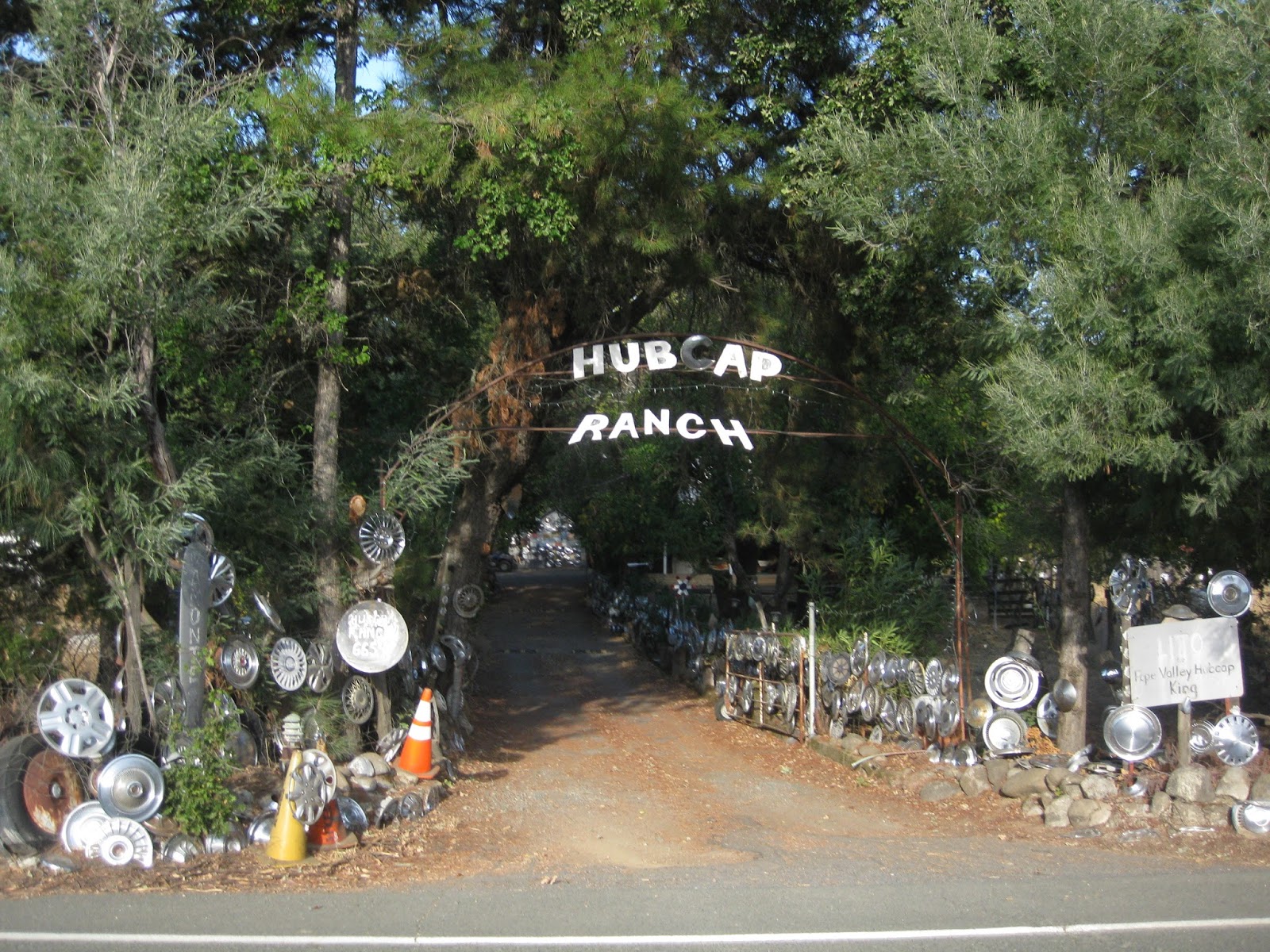
Hubcap Ranch


We seemed to be making up quite a bit of time from our easy going morning pace and were getting stronger as the ride went on.
We were now doing most of the climbs without the granny gear. We just didn’t seem to need it.
Just another of many climbs. It seem like the second half had more nice descents in between the climbs.

The next stop which I will call “the hotdog stop” was at the bottom of a great descent. We just flew down that technical descent. I told Teresa that in years past I remember I always would get the cold chills on this descent as the temperature really starts to drop at this point of the ride and in this canyon. This year it was cool but warm enough that there wasn’t a chill in the air. It was great.

It’s very easy to miss the turn into this check point. Many people did miss it and just kept rolling down the hill. There is a big sign out front for the turn down a small road leading to a park.
This stop is the perfect example why people need to follow their route slip and check the mileage to make sure when they are getting close so they can keep their eyes peeled for the turn sign. It was a nice big sign and not easy to miss unless you are not paying attention.

There was a big group of people at this stop. It seemed we were slowly making time on many who were now slowing later in the event. This is where having experience pays off. Taking it easy in the morning on the first 100 miles was paying dividends.
I wolfed down two hot dogs with lots of mustard. They were so good!
 I don’t eat hot dogs too often but the massive amounts of sodium and fat seem to really hit the spot at this point.
We spent a good bit of time here talking to friends and recovering.
Hot dog stop with friends John and Shelby. John called his ride short at around 70 miles and then volunteered the rest of the day. What a guy!

I know its not a horse trailer but a good place to park this beast. 


Coming ahead was the home stretch and we were getting stronger!

Check Point 5 to the final stop
Mile 152-181


We rolled out of the stop feeling great. We continued the descent of the canyon for just a little bit until we reached Lake Hennesey on the right. The sun was setting just behind the mountains to our right and it was really beautiful. We were not far from where we were in the morning when riding through the Napa Valley. It was just a few miles as the crow flies to our west.
Lake Hennessy 

We now had another climb on a butter smooth road. Hwy 128 was great. It was a gradual climb to start with and seemed really easy. It seemed that as long as the grade is 5% or under, we can climb really well on my really heavy tandem. Once it goes above that gradient you can really feel the weight.
We were catching a bunch of our friends up ahead on the gradual part of the climb but as soon as it kicked to closer to 9% near the top, they disappeared. I thought to myself…..Maybe we will join up on the next one or on the descent of the other side.
Climbing the butter smooth highway after the stop.

Summit of one of the final climbs as the light gets dim.

We did catch them just before the summit of the next little climb after this descent. They were stopped putting on some more layers of clothes because it was starting to chill down a bit finally.

I have to mention a comical moment we had when we passed them.

It went like this.

Teresa yelled out her normal Tiger growl as we passed them. Then our friend Terri yells out…..”What do you mean passing us you harlot!!”
I started laughing uncontrollably and almost lost control of the bike. Then out of Teresa’s mouth as we both stopped laughing……..”What’s she mean. What’s a harlot?!”
I then commenced trying to explain to her what a harlot was.

Ohhh….man….did we have a laugh on that one once she realized what it was.
I guess my stoker has a reputation with her fiery personality …..LOL.

We soon stopped ourselves. I put on a vest so I could keep my core warm on the descents and my knee warmers. Warming up my knees really made my legs feel great at this point.
Terri and our friends passed us as we did this and we had another laugh….Teresa yelling at Terri…..”What do you mean calling me a harlot”!
I think the natural drug known as endorphins were starting to kick in big time. We shouldn’t be having so much fun at this point in an ultra-event…..should we?
Feeling great with only about 30 miles to go, we rolled on.

It was now getting dark as we rolled once again around Lake Berryessa. We had the final good little climbs as we went around the south end of the lake with the summit up by the dam.

From this point on, it is a tandem friendly course all the way to the final check point and the finish. Mostly downhill with rolling hills which you can roll over easily with the speeds you are able to attain on a tandem leading into them.

We traded back and forth with some on the final climbs around the lake and then we were passed by a group of faster riders who had done the highland route. They passed us on the final climb to the dam.

When we reached the summit we were happy. I put the bike in overdrive and we took off. We flew past countless people and just hammered to the next check point. I really couldn’t believe how much power we had on this final stretch. We rolled into the final stop planning for a short stop then a recovery pace to the finish which was really easy and only 13 more miles.

I topped off with a little water and grabbed a few things to eat.
All the people we had passed were saying….”Let’s make sure we roll with the tandem to the finish. They will pull us to the finish”!

The instigator of this was my friend Roehl from the Fresno area and the group we had passed were his friends from the area. Roehl had just finished a lightning fast Silver State 508 Solo race just a few weeks prior to Knoxville.

My hot foot had started kicking in just before the stop and I was a little iffy about hammering in a big gear to the finish. It turned out to be a really fun laugh-fest though.

Final check-point to the finish
Mile 181-195

We rolled out onto Pleasants Valley Road toward the finish starting with a little climb. Roehl and our group stayed with us instead of hammering up to the summit and waiting for us to catch them. I guess they were tired too.

As soon as we reached that little summit I started cruise mode and just kept a nice steady pace trying to spin more than push the big gears. My feet were toast at this point like they usually are on the tandem.
We had some good laughs. Roehl kept going to the front saying he was going to let us draft him and then he would go way up ahead and we would all yell at him….”How can we draft you if you are way up there”?!
It was hilarious. We had some good laughs and reeled in countless people on that final section.

Our little group rolled into the finish at about 9:05 pm and had a great dinner at the park. My friend Lynn was handling the dinner with her guy Eric.
Done and ready for dinner


This was such a beautiful course. As I said it is one of my favorites. I wish I could ride more up in the area. 

Ride stats:


Distance:                   195.5 miles
Ride time:                 14:19
Elapsed time:            16:42
Elev. Gain:                12,831 ft

_____________________________________________________________________

As I write this, much of the area we rode through is being destroyed by fires. It just breaks my heart to see what is happening up in Napa/Sonoma.
My thoughts and prayers are with the thousands who have lost their homes or businesses. It’s just terrible.


The following day, many of us got up to help with the Triple Crown Awards Breakfast at the park. We had to be there about 6 am and helped with prep and cooking for all who would come to the breakfast.

Congrats to all those who did their first triple crown and to all those who were inducted into the hall of fame at the breakfast. 

Here are a few pics from Sunday morning:


Cracking 100's of eggs


I was on bean duty too

With some of my best cycling buddies, Russell, Dzung, John, Quynh, George and Daniel. Ive put a lot of miles in with these guys.

Grub is on!!


We got up early the following morning to help cook breakfast for all those who came to the Triple Crown Awards Breakfast. It was a great party and we had a blast. 

Summer and Fall 2025

  After getting through my back surgery ordeal and finally doing my 200th double century back in June, I decided to round out the year with ...