

Well, doing an event this spring has turned into a real challenge, and it has been devastating for the event organizers who were forced to cancel all the spring events due to the Covid-19 pandemic.
I, myself, have not slowed down in my training. I am very afraid to stop my training at my age. At almost 68 years young, I know that coming back from "downtime" is much harder as you get older.
I have been training but not at hard intensity.
On my climbing rides, I have been taking it as easy as I can and on the long flat ones, I am just pacing myself.
You know....its funny. I am ahead of my schedule on my yearly mileage by hundreds of miles, even though I have not done a double century event yet this spring. The last event was the Southern Inyo Double on March 7th before everything hit the fan.
I have been doing more miles and getting more rest. My resting heart rate has gone down a lot and I am sleeping better. Go figure.
Event organizers and The California Triple Crown have gotten creative in these trying times.
We now have "Virtual Events" where a person can do the event virtually on a home trainer or do it outdoors.
If outdoors, you are required to keep social distancing and not ride in large groups of more than 10 people.
The rules state that virtual events must encompass close to the same mileage as the real event and have close to the same elevation gain.
Outdoors, of course, you could do the actual course but you are not required to since many people would have to travel and stay somewhere overnight to do this.
I can not stand riding on a trainer, especially for the amount of time required, so I choose to ride outdoors. It is much healthier.
This brings me to The Heartbreak Double Century and The Eastern Sierra Double Century
The Heartbreak Double. (Virtual)
I created my own course for this double century. (I added about a mile with another little climb toward the end, I was feeling so good at the time.)
- Part one: Home to Ojai, Ca.
I had the Friday off, so I decided to do it then. A bunch of friends planned on doing the actual course on Saturday but I had to work.
This was the first date allowed to do the Virtual Heartbreak. (The ride has to be done between certain dates near the actual event date on the calendar.)
I am signed up for the Hoodoo 500 in August in the Nomad, self-supported, division, so I looked at this as excellent training.
I started the ride at what my friends call, "Steve early".
This turned out to be a start at about 3am.
I actually got a pretty good night's sleep for a change.
After a very fun Zoom meeting on the internet with cycling friends, I went to bed before 9 pm.
I popped awake before my alarm went off and felt surprisingly rested and fresh. I wish that would happen more often before some of my regular events. I am usually so tired at the start of events that my heart rate is too high.
My plan was to get out of the city area early and get into the mountainous zone around sunrise.
This worked out very well.
I did the ride self-supported and again carried everything but the kitchen sink. I did not want to stop for food anywhere and I scoped out where the parks were so I could get water. I carried all my food and supplements with me. (It turned out I had to stop for food twice. Just could not carry enough with me on this one.)
After leaving the West Hills area I made a trek around Chatsworth Lake over to Santa Susan Pass.
It was amazing how loud the mocking birds were in the wee hours of the morning. Other than that, a few owl hoots, and the distant sound of the 118 Freeway in the distance, it was a very peaceful climb with not one car.
 |
| Looking back at a gorgeous moon and the west San Fernando Valley from the halfway point on Santa Susana Pass |
Over Santa Su, I went to Simi Valley where I traversed the north side of the valley in the hills before reaching Moorpark.
From Moorpark, I went up and over Grimes Canyon to the Santa Clara River Valley where I headed west down the beautiful valley with the sun rising behind me.
 |
| Grimes Canyon Summit |
 |
| Descending Grimes Canyon |
 |
| Santa Clara River at sunrise |
 |
| My shadow as I look west toward Ventura |
I was now on the Tour of Two Forests course which took me up to Ojai from the South on Dennison Grade.
Once reaching upper Ojai, I stopped at the fire station to fill up my camel-back and two water bottles.
I now had a very long, but oh so beautiful climb, up Maricopa Hwy to Sespe Gorge for the turnaround.
 |
| Descending to the Ojai Valley from the upper valley. I will be climbing those mountains in the distance very soon. |
- Part 2: The real climbing begins
This climb is about 18 miles long starting from Ojai. It starts with an elevation of about 750 feet in Ojai to my turn around at about 3,500 feet. It is just a long climb. There are no real steep sections, just a steady 4-7% grade all the way.
I descended down into the gorge for a little bit and turned around near Sespe Gorge.
 |
| A few short tunnels on the way up |
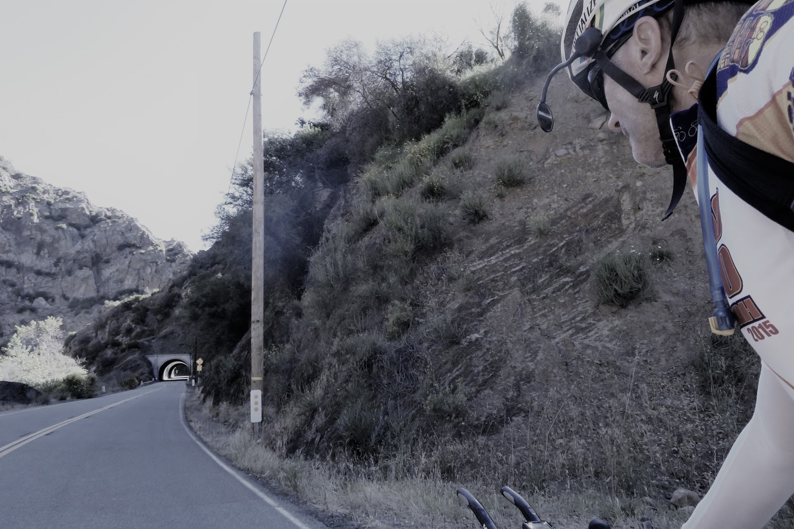 |
| Tunnels |
I had a tailwind at this point. It was still pretty cool but with the tailwind, I was starting to get warm.
It is good that I started really early. Not sure how much hotter it would have been later in the morning.
I stopped for a short break at the campground.
 |
| A great place for a rest stop. Too bad they did not have any water here. Glad I planned accordingly. |
 |
| You can see the road snaking up that mountain in the distance |
I did get a bit overheated at one point and needed to stop for a break in the shade.
 |
| Almost to the summit. The climbing becomes pretty easy from here. |
 |
| Summit of Wheeler Grade. Time to descend a bit to Sespe Gorge before turning around. |
Below is a short video pan of the area.
I descended about halfway down into the Sespe Gorge before turning around and climbing back up. Once back up to the top, I took a food break.
I used some leftover fajitas and rice to make some burritos for the ride. It was so good and refreshing.
- Part 3: Summit to Ventura
The descent down was amazing. I was not able to maintain the speed I wanted because now there was a good headwind coming up the Gorge from the coast. Did this mean I was going to have a great tailwind heading back southbound? I certainly was hoping so!!
The first part of climbing this grade is very easy. The upper part is not too long but it is the steepest gradient of the whole ride at close to 10% at one point. I just paced myself.
 |
| Casitas Pass Summit |
Then comes a great descent again into a headwind.
The last time I did this descent was on last falls, Dead of Winter Double Century. On that occasion, it was pouring rain and I was freezing. Glad it wasn't like that this time.
There is a method to my madness as far as my early start. I was hoping that according to the weather reports, I would get the usual tailwind on the next leg of my ride.
I made a left turn on Hwy 1 at the coast on to the bike path heading south. The winds were, unfortunately, out of the South, for my cruise to Ventura before heading inland.
They were not too strong but at this point, I was out of the water, and I could tell I was getting a bit dehydrated. I was feeling a slight bit of cramping coming on in my inner thigh. Not a good sign!!
 |
| Rolling past Rincon Point on the Hwy 1 bike path into a slight headwind. |
I stopped at the drinking fountain at the Sea Cliff Fire Station and filled up my camel-back and two bottles with Tailwind Endurance Fuel. This has plenty of electrolytes in it and I was hoping I did not get too far behind on my hydration when it was cool out.
You really have to make sure you drink enough when it is cold too. Not drinking enough may be ok if it stays cool all day, but if it drastically goes from cool to hot rapidly, you may be in trouble. I was just hoping that I caught it on time.
 |
| Heading toward the bike path leading into the town of Ventura |
 |
| Brand new pavement on what used to be a very rough bike path |
I was so tempted to stop at Tony's Pizza in Ventura to get a slice but I used my will-power and kept going.
From Ventura, I headed back to the Santa Paula area via Foothill Road.
I started to get some pretty bad cramps in both legs, between Ventura and Santa Paula. I also had a really good tailwind starting to kick up as it got hotter inland.
I was now running out of food too, so I really could not push hard and take much advantage of it since I couldn't push on the pedals hard at this point. There were some pretty good kicker hills on Foothill Road for a while so this section was not as fun as it could have been.
I stopped in Santa Paula at an AM/PM for a sandwich, some salty chips, and a soda. I picked up a little bit more food for the road too, just in case.
I still had enough water to barely get me to Santa Clarita. They were out of bottled water at the store.
I ate half the sandwich and about half the salty chips. I guzzled down the soda and took off quickly.
The station had good social distancing protocols in place and I wore my mask into the store. There were not very many people inside so it was ok.
I now backtracked along the same course I had done in the morning and then continued East Bound past Grimes to the Piru area and then Santa Clarita.
 |
| Heading east on Guiberson Road |
 | ||
| Heading east on Guiberson Road. Look at those giant cactus's!!
I started recovering nicely along this stretch. The tailwind helped, although, I still needed to be easy on the crampy legs and conserve my water.
When I made it to Torrey Road and Hwy 126, the tailwind was really picking up nicely and it was cooling off some. This made a huge difference! I made it to the Magic Mountain area really fast and stopped at the fire station right after exiting the highway. I was totally out of water and they did not have water access like the Ventura County stations have. (Get with it LA!!!)
That meant stopping at a store again. Arrggghhh!! I was now feeling so good that I could have made it all the way home picking up strength if I had water.
It was only a couple of miles to the next station with a store so there was not a problem. I now had a blazing hard tailwind coming out of the north that was blowing the huge flags straight south. What a great reward!!!!
As it cooled now.....I was feeling really strong and getting my legs back. I almost felt better than I had all day. Go figure.
|
 |
| Magic Mountain |
I stopped at the Chevron Station store just past Magic Mountain on The Old Road. Again, the store was set up really well for the virus situation.
I got a large bottle of water and I guzzled a large coconut water. (the was really good)
I filled the two water bottles but not my pack. Two would get me home easy with this cool weather and tailwind. I finished the last half of my ham and cheese sandwich which I had purchased at the last stop in Santa Paula.
One more large bump to negotiate and I would be back in The Valley, Newhall Pass.
This was an easy climb but with so many miles in the legs, every climb seems hard.
I really surprised myself though. The climb over the pass seemed effortless. (Must have been the coconut water).
I stopped at the top to check-in with home and take a few pictures. There was still plenty of light out and the wind was howling over the pass in just the right direction.
 |
| Newhall Pass looking south |
 |
| Newhall Pass looking North |
The sun was setting as I reached Chatsworth Lake.
I rolled around the lake and then did one final hill on Valley Circle before dropping to the house.
I made it in the door with just a little bit of light left.
What an epic day on the bike. A solo day to be with my thoughts and just enjoy the views.
I loved this ride!!
 |
| Valley Circle and Box Canyon Roads. Almost home. A couple short climbs to go and about 5 miles |
Stats for my Heartbreak Course:

Virtual Eastern Sierra
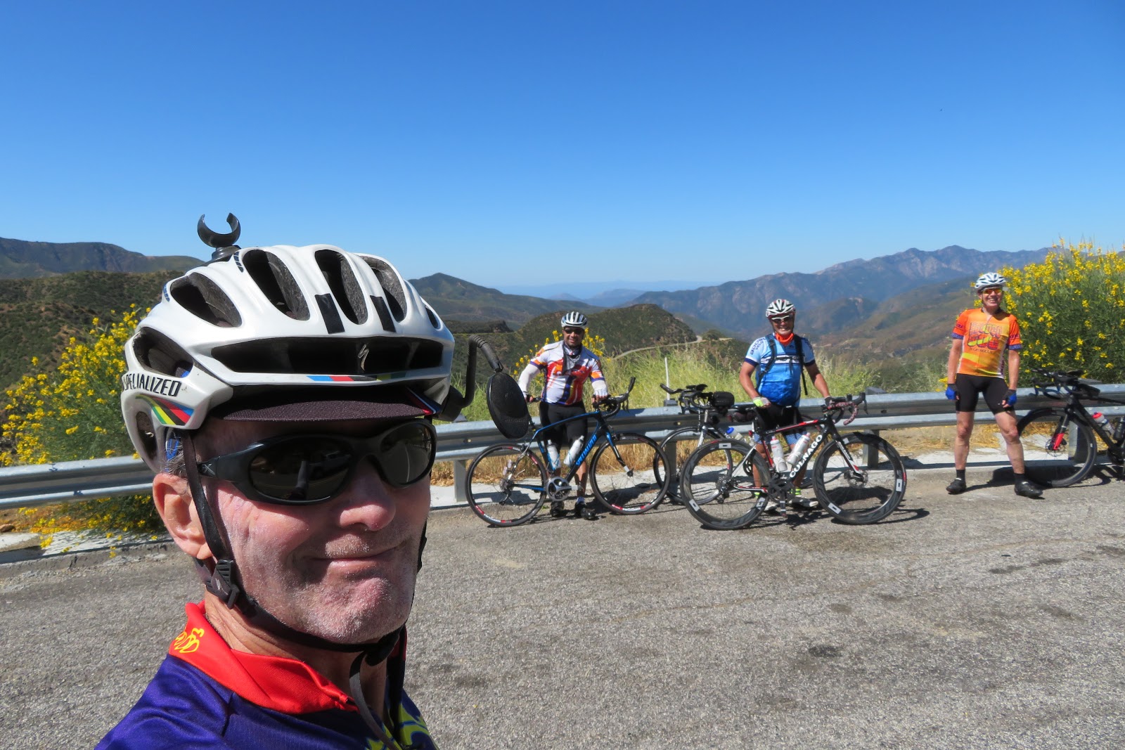
Some of my fellow endurance riders asked me to join for their virtual course a couple weeks after my above Heartbreak course. We had nine people with a support vehicle to carry all our gear, food, and water.
It was great fun with a group of very healthy riders who have been taking great care to stay healthy during these tough times.
We did a course out of Malibu, Ca. that was very close to the highland Grand Tour course with some extra climbing so we would qualify for the Eastern Sierra (Virtual) which had to be close to the same elevation gain and mileage as the original event up in Bishop, Ca.
We started up the coast and turned on Encinal Canyon for a long climb up to the Decker Canyon fire station before dropping back down to PCH. We then went to Port Hueneme, Moorpark, Ventura, and Ojai. We did a large climbing loop out around Ojai before heading west for the climb over Casitas Pass to Carpenteria. It was then a long slog back south-bound to Malibu for the finish.
We had perfect conditions. Cool and breezy all day, with a headwind in many places especially climbing out of Ojai.
The final 60 or so miles we had a fantastic tailwind. It was one of the best tailwinds in recent memory.
We finished before dark with a pretty good time overall.
A great day with friends on the bike. A big huge thanks go out to Planet Ultra and the California Triple Crown, for allowing us to do the events we love so much and get credit for them. This was a great idea in this trying time.
A few pics from the day.
 |
| Heading north on PCH at first light. |
 |
| Climbing the lower slopes of Encinal Canyon |
 |
| Me and my shadow climbing Encinal Canyon Robert Mann descending Encinal on his fixed gear. |
 |
| Heading into Ventura County on PCH |
 |
| Dee and I climbing Casitas Pass |
 |
| Robert Mann climbing Casitas Pass on his fixed gear bike. |
 |
| Rincon Point |
 |
| The new bike path heading in to Ventura |
 |
| Rolling past Mugu Naval Air Station |
 |
| Not far to go. Leaving point Mugu behind and heading toward Malibu. You can see point Mugu in the distance. |
We endurance riders really appreciate having met our goals for finishing these events.
Stats for my Eastern Sierra (Virtual) Course:

TOUR OF TWO FORESTS
It has been a few years since I have done TOTF. This year we had the option of doing it on a total virtual course as per the rules, or do the actual course out of Santa Clarita. (The actual course had a few modifications to bring the climbing and mileage down a slight bit per the "virtual" guidelines.)
I opted to do the ride on the actual event day on the actual course. Since the start is so close to my house (about 21 miles), I decided to start from home like I did in 2015 when in training for Hoodoo Voyager division.
It was a great training ride that year. The course simulates the arid climate and climbing of Hoodoo too.
This year I am training for the Nomad division which is the 300-mile course. It will be my Hall of Fame ride so I am really excited about doing it.
I started from home around 3:30 am so I could make sure I made it over Newhall Pass and into Santa Clarita before everyone started at 5. We had, as per the rules, a group of no more than 10 people. There were more than that doing the event, but everyone was broken into groups and had different SAG support.
We rolled slightly after 5 at a pretty brisk pace.
The course rolls through Santa Clarita along The Old Road which parallels Interstate 5 until you reach Hwy 126 which goes to Ventura before connecting with Hwy 101.
We were on the 126 for a few miles of very fast pace-line riding until we reached the town of Piru which is just below Lake Piru.
We then followed the Santa Clara River all the way to Santa Paula.
It was then up to Ojai via Dennison Grade before connecting to Hwy 39, Maricopa Hwy.
The climb up Dennison Grade was not bad and pretty short. Temps were nice and cool.
Once we hit Hwy 39, the climbing got real. It is a long, long, climb up Wheeler Gorge before the first summit.
Now we had to drop into Sespe Gorge and start the long climb to the summit of Pine Mountain.
This section just seemed to be endless.
We passed the section of the mountain that came down in the El Nino in the '90s. You can see where the mountain was gone.
The course for TOTF was closed for many years which was the birth of The Heartbreak Double Century. (it was at first called TOTF but was changed later)
Once over Pine Mountain Summit, we had a long descent to Lockwood Valley Road where we had lunch before heading for Heartbreak Hill.
It had been windy all day thus far. We now had a great tailwind for the climb.
The wind was strong enough that it kept us cool on the normally very hot climb over Heartbreak, Lockwood, and Owls Barn summits.
It was then a blazing descent to Frazier Park and Lebec before heading back to Santa Clarita via Gorman, Hwy 138, and Elizabeth Lake Road.
We climbed and descended San Fracisquito Road to get back to the finish instead of Bouquet Canyon which is on the original course.
We all had a great day and actually finished in daylight. Amazing!
Here are pictures of another epic ride.
 |
| Tony on his fixed gear bike |
 |
| Sunrise along the Santa Clara River |
 |
| Shadows at sunrise |
 |
| Margaret and Ron in Upper Ojai Valley |
 |
| Margaret and Ron heading for the tunnels on Hwy 33. |
 |
| Almost to the summit of Wheeler Gorge |
 |
| The flowers were really fragrant on the Hwy 33 climb |
 |
| Margaret smelling the flowers |
 |
| The Summit above Ojai before dropping into Sespe Gorge. |
 |
| The long climb out of Ojai |
 |
| Margaret descending into a very windy Sespe Gorge |
 |
| Water stop just before the final climb to the summit of Pine Mountain |
 |
| Lunch |
 |
| Lunch nap for Tony, in the sun |
 |
| Two of the fixed gears. Tony and Rick on Lockwood Valley Road |
 |
| The final climb on Heartbreak Hill |
 |
| The final switch-back on Heartbreak hill. It still isn't over though. It still climbs pretty steeply from here. |
Tony climbing Heartbreak on his Fixed Gear bike. Just craziness!!!

 |
| The final main climb |
 |
| Summit of San Francisquito Road. A long descent awaits us. |


No comments:
Post a Comment