
A short prelude:
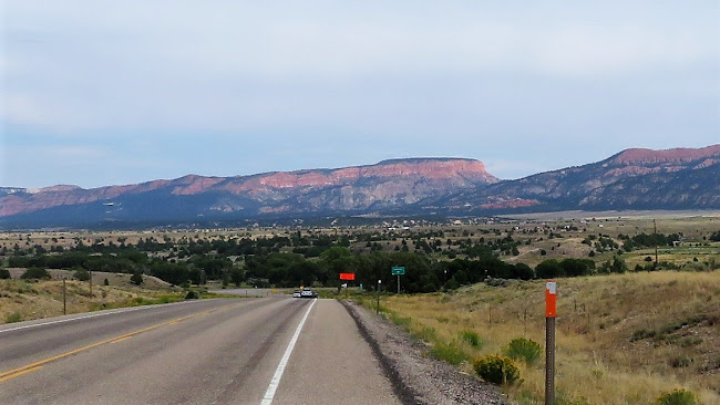
The Hoodoo 500 starts in St. George Utah. The course is a large elongated loop that drops into Arizona for just a bit before heading through some of the most beautiful scenery on earth.
I have used this prelude before. I don't know a better way to describe this race than to quote Planet Ultra, the race organizer. Below is their explanation of this race.
“The most epic and challenging ultra-cycling race, the Hoodoo 500 route passes through or around three National Parks, three National Monuments and several Utah State Parks. The scenery varies from majestic cliffs and striking red rock hoodoos to aspen and pine forests and high mountain meadows. All the best of Utah’s Color Country!
Geologically speaking, hoodoos are tall, skinny spires of rock that protrude from the bottom of arid basins and sedimentary rock.
Mystically speaking, hoodoo means a magical spell; which is what the Hoodoo 500 experience will cast upon you.”
As I have said before, I totally agree with what it says above about this experience casting a spell on you.
After doing the event for the first time in 2014 as a 60+ division solo racer with a crew, 2015 in the Voyager self-supported division, 2016 in the 2-man team division, and 2019 in the 500 mile stage race, I was really excited to do it again.
This would be my 5th Hoodoo 500 making it my "Hall of Fame" ride if I finish.
This year I thought I would do something different again.
I decided last year that I would come back and do the Nomad division.
I wanted to do it self-supported again but at my age, I don't think I could handle doing 500-mile Voyager division again.
Nomad division is a self-supported race but you do the 300-mile course instead of the 500-mile course. The 300-mile course is done without the loop out to Escalante, Boulder, Boulder Mountain, and returning to Panguitch.
The 300-mile course goes direct to Panguitch without that loop and cuts out some climbing too. The current 500-mile course has a little over 30,000 feet of elevation gain. The 300 miler has around 17,300 feet.
This year with the Covid-19 pandemic, things were done a little different with check-in and the pre-race meeting. Everything was done following the CDC guidelines. Check-in was done one racer at a time. I got done with checking in early then went to get my hotel room and rest for a while prior to the meeting at 6:15.
The meeting went well as usual. I got something to eat and tried to get down early to sleep. My race division started at 5am in the morning.
A little side-note:
I was trained really well for this race. I did a lot of heat training and climbing, with much of it done carrying a lot of weight and a pack on my back, with very few stops as I would be required to do in the Nomad division. In hindsight, I think I did not do enough altitude training as I would soon find out. When I tried to sleep in the dry desert air of St. George Utah, I had a hard time. I felt like I was already dehydrated just being there. My normal resting heart-rate of 48-58 BPM was at 90 BPM just trying to sleep. I just did not feel all that good.
Some, of course, was caused by anxiety, but I think most of it was just trying to rush from home to an event with not enough rest. I should have come up at least a day early with a little riding to get acclimated and remove some of the jitters like I did in the past.
There were only me and a young woman, Emily who came all the way from Colorado, doing the Nomad Division.
There really are not too many people willing to put their minds and bodies through this type of suffering.
For me, it is a true zen type thing being out there all by yourself in nature braving the elements.
We started with the Voyager Division racers at 5am.
There were 3 very well known Ultra-Racers doing Voyager and one very young man who was not so well known to all of us on the circuit. His name was Max and he is Emily's brother who is also from Colorado.
The other racers were David Hasse, Brook Henderson, and Kevin Bilbee.
Dave, from Wisconsin, is a seasoned Race Across America veteran with 7 RAAM races. He completed 5 of them with 2-second place finishes. He was the overall solo winner of this year's 1,000 Kilometer, 42,000 ft., Race Across Oregon (RAO) and he did it self-supported without a crew!!!
Click HERE for an older article from Bicycling on Dave. Good article.
Brook lives just down the street from me and is a good friend. He is a past course record holder at Hoodoo and an incredibly strong rider. He also did RAO. He did it on a 2-person mixed team with our friend Lori who won the 500-mile stage race at this year's Hoodoo in the women's division.
Kevin Bilbee is from Apple Valley California in the heart of the Mojave desert, just down the hill from the big mountains of Big Bear Lake. Great training grounds for this race. He is a veteran of the self-supported Silver State 508. He killed it last year but as he said when he finished this year's Hoodoo, "this was the toughest race I have ever done".
Now let's get back to Max. Well...Max is very young. I think he is in his late 20's or early 30's. In order to qualify for Voyager, you need to show that you can survive this type of race. They will not let you in otherwise. It is that tough.....believe me...I know from experience.
Guess what Max did. He completed the Trans American Bike Race. This race is fully self-supported starting in Oregon, crossing the Northern part of the USA, and finishing at the Atlantic Coast. I think the race works out to close to 4,200 miles! An amazing accomplishment.
Side-note: To enlarge pictures just click on them.
This would be my 5th Hoodoo 500 making it my "Hall of Fame" ride if I finish.
This year I thought I would do something different again.
I decided last year that I would come back and do the Nomad division.
I wanted to do it self-supported again but at my age, I don't think I could handle doing 500-mile Voyager division again.
Nomad division is a self-supported race but you do the 300-mile course instead of the 500-mile course. The 300-mile course is done without the loop out to Escalante, Boulder, Boulder Mountain, and returning to Panguitch.
The 300-mile course goes direct to Panguitch without that loop and cuts out some climbing too. The current 500-mile course has a little over 30,000 feet of elevation gain. The 300 miler has around 17,300 feet.
This year with the Covid-19 pandemic, things were done a little different with check-in and the pre-race meeting. Everything was done following the CDC guidelines. Check-in was done one racer at a time. I got done with checking in early then went to get my hotel room and rest for a while prior to the meeting at 6:15.
 |
| My mugshot |
The meeting went well as usual. I got something to eat and tried to get down early to sleep. My race division started at 5am in the morning.
A little side-note:
I was trained really well for this race. I did a lot of heat training and climbing, with much of it done carrying a lot of weight and a pack on my back, with very few stops as I would be required to do in the Nomad division. In hindsight, I think I did not do enough altitude training as I would soon find out. When I tried to sleep in the dry desert air of St. George Utah, I had a hard time. I felt like I was already dehydrated just being there. My normal resting heart-rate of 48-58 BPM was at 90 BPM just trying to sleep. I just did not feel all that good.
Some, of course, was caused by anxiety, but I think most of it was just trying to rush from home to an event with not enough rest. I should have come up at least a day early with a little riding to get acclimated and remove some of the jitters like I did in the past.
Now to the awesome race
 |
| 300-mile course |
There were only me and a young woman, Emily who came all the way from Colorado, doing the Nomad Division.
There really are not too many people willing to put their minds and bodies through this type of suffering.
For me, it is a true zen type thing being out there all by yourself in nature braving the elements.
We started with the Voyager Division racers at 5am.
There were 3 very well known Ultra-Racers doing Voyager and one very young man who was not so well known to all of us on the circuit. His name was Max and he is Emily's brother who is also from Colorado.
The other racers were David Hasse, Brook Henderson, and Kevin Bilbee.
Dave, from Wisconsin, is a seasoned Race Across America veteran with 7 RAAM races. He completed 5 of them with 2-second place finishes. He was the overall solo winner of this year's 1,000 Kilometer, 42,000 ft., Race Across Oregon (RAO) and he did it self-supported without a crew!!!
Click HERE for an older article from Bicycling on Dave. Good article.
Brook lives just down the street from me and is a good friend. He is a past course record holder at Hoodoo and an incredibly strong rider. He also did RAO. He did it on a 2-person mixed team with our friend Lori who won the 500-mile stage race at this year's Hoodoo in the women's division.
Kevin Bilbee is from Apple Valley California in the heart of the Mojave desert, just down the hill from the big mountains of Big Bear Lake. Great training grounds for this race. He is a veteran of the self-supported Silver State 508. He killed it last year but as he said when he finished this year's Hoodoo, "this was the toughest race I have ever done".
Now let's get back to Max. Well...Max is very young. I think he is in his late 20's or early 30's. In order to qualify for Voyager, you need to show that you can survive this type of race. They will not let you in otherwise. It is that tough.....believe me...I know from experience.
Guess what Max did. He completed the Trans American Bike Race. This race is fully self-supported starting in Oregon, crossing the Northern part of the USA, and finishing at the Atlantic Coast. I think the race works out to close to 4,200 miles! An amazing accomplishment.
Side-note: To enlarge pictures just click on them.
90.8 miles
Elevation gain: 5,930 ’

 |
| Voyager Dave Hasse and I at the start |
We rolled out right on time at 5am for the 8-mile neutral section of the race. We all stayed together and chatted during this section. It was sort-of, a warm-up.
I could tell right off the bat that I was in trouble. From the time I got up in the morning, I knew.
On my usual training rides, I really monitor my heart rate. I use that to tell me how recovered I am from training or racing (or just my work for that matter). I use an App called HRV4TRAINING. This App is used to monitor your recovery rest and can tell you if you are overtrained as well as many other things. It even responds to the prior day's alcohol intake.
It reads you Heartrate Variability which can tell you all sorts of things. My HRV reading was telling me that I was really ready and rested well for the race, but due the traveling and lack of rest just before the race, I had a reading on the low side.
My HR was so high already at the start of the race, and I was not ever working hard at all. I also did not have a lot of power. I was going at a pace that in training, my HR would be 105-120 but just starting out this race my HR was close to 140. This was the first issue.
Even with this situation, I was able to keep a good steady pace as I did not push it too hard on the climbs, and Oh-boy there are a lot of those.
Once we got to Washington Dam Road, we started racing.
There was no way I was going to make the mistake of trying to stay with all the other racers. I am 68 years young and that would be a disaster. Emily, my fellow Nomad is only in her late 20's and the oldest Voyager racer was in his early 50's. It would be suicide for me to do that.
I just tried to keep my HR steady as much as I could and hoped that it would start equalizing once I got my second wind and some of the jitters out.
This was very hard because right out of the box we had a long climb heading to Hurricane Utah. From there we had a nasty climb toward and into the Northern Arizona area before it leveled a little bit to just rolling hills.
This was a very beautiful section at the sunrise. We got very lucky as far as the heat on course this year. The monsoon was in town and there were storm clouds all around with some high overcast which kept it very cool for the whole day of the Nomad race.
 |
Heading toward Northern Arizona. Look where they installed the rumble strips. And no shoulder!
|

 |
| Boy was it pretty on this morning!! |
There were some pretty good climbs on this first stretch but with my HR they were tough.
There was one section of highway where the road workers had put the rumble strips right on the white line. There was no shoulder on much of it, so you were forced to ride in the traffic lane. Luckily there was not much traffic at our start time but it was pretty stressful non the less. This was the major highway going to Lake Powell from Southern Utah. Lots of RV's.
It was a really beautiful section through there though and it made it all worth it.
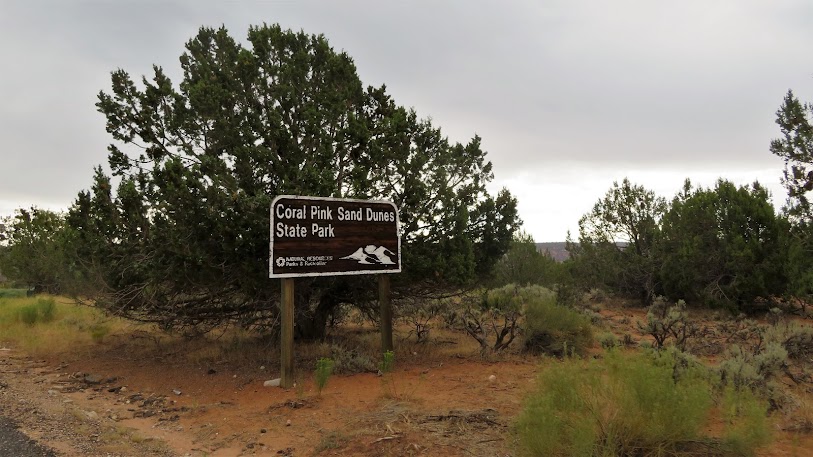
At mile marker 53 I made the turn toward the Coral Pink Sand Dunes State Park. It just became a magical ride from this point on as usual.
Last year in this section it was over 100 degrees. This year, there were rain clouds around but just a few drops here and there. The temperature was in the upper 70's to low 80's. It was wonderful.
 |
| Coral Pink Sand Dunes State Park |
 |
| Cowboy! |
We had about 28 miles on this section which cuts us over to Highway 89. There were hardly any cars and it was just beautiful. The only people I saw were a few campers and some cowboys riding horses with their sheepdogs. We had a few short climbs through this section but most was just a gradual climb up to Hwy 89.
I was feeling worse as I gained altitude which was already forcing me to make rest stops. On my training rides, I normally will go pretty fast for about 70 miles without stopping when I am carrying a lot of water and food with me. This time all the weight I was carrying was causing my hot foot to kick up on top of the loss of power issue. (I was already starting to think I had not done enough altitude training and I was not even to the epic altitudes yet that this ride is known for.
I stopped for a minute at the Highway 89 turn and ate some food.
I had a really nice descent and a few small climbs before reaching Time Station One at Forscher German Bakery about 9 miles from the turn. Boy was that a welcome sight!
I rolled in at 11:44am.
I had a nice meeting with Dave and Connie who were hosting the time station. Really nice people. They got me some water and I got my food out of my drop bag for the next section, the 44 miles to the next time station, which can be tough if it gets windy and hot.

 |
| Dave and Connie |
Self-supported racers have no support other than your drop-bags which are brought to points on the course. They have your clothes and supplies for topping things off. Luckily I did not need any warmer clothes on this section other than what I was wearing. I had a vest and rain jacket with me at all times. Water is available at the time station. My really warm layers were at the next time station.
I did not have much in this one other than an Ensure and a coke as well as my powdered Tailwind Endurance Fuel which I put in my Camelbak water reservoir.
Part two: TS One, Forscher German Bakery to TS 2, Panguitch
44.0 miles.
Total miles: 135.4
Elevation gain: 2804'
Accumulated elevation gain: 8,734’

Off I went.
The solo racers with a crew started at 7am and it is usually not far from this point that the really fast solo people start to pass the self-supported racers. You just can't go that fast carrying all that extra weight unless you are one of those younger racers.
Not far from leaving, the wind came up and a big rain squall showed up to my right. It started to rain but never really got the road or me all that wet. The temperature really dropped though. It went from the mid-'80s to about 65. It felt really good. I never needed to put my rain jacket on because it didn't rain long enough to get me that wet. I dried off almost immediately.
After I got past Mount Camel Junction, the ride was really nice and I had a good tail-wind. The Red Canyon area started to come into view at my right. It was so beautiful, I just had to take a lot of pictures. Green pastures with a meandering river going through it and the mountains in the distance. Magical stuff!!

 |
| Heading toward Hwy 12 |


I stopped for a second at the junction of Hwy 12 and Hwy 89.
This is where the 500-mile race leaves the 300-mile course and heads towards Bryce and Boulder Mountain. Arguably, the most beautiful section of the Hoodoo 500 but much of it is done in the darkness of night. You usually get to see the section between Red Canyon and Escalante in daylight but then you climb over Boulder Mountain in the dark. When I did the Voyager division in 2015, I had the super moon that evening. It was spectacular. The canyon before the town of Boulder was glowing orange in the dark and I could almost see everything.
 |
| 7 miles to the time station |
Just a few miles to Time Station 2 for me now. I rolled into time station 2 at 3:18pm feeling pretty bad. It was mainly hot-foot which was slowing me down at this point as well as the common altitude problems.
Part 3: TS 2, Panguitch to TS 3 Cedar City
69.5 miles.
Total miles: 204.9
Elevation gain: 5,497'
Accumulated elevation gain: 14,231’

I hung out, way too long, at the time station.
I had to figure out what cold-weather gear to bring with me. There were some clouds around but most of the storms seemed to be dissipating. It was in the '80s and windy.
The climb to the Cedar Breaks area at 10,000 feet is notorious for freezing racers with either bone-chilling cold temps or freezing rain/hail or snow, even in these summer months. There are many stories.
I decided to bring a vest, Showers Pass Double Century Jacket, wool base layer, leg warmers, waterproof wool gloves, a head and face buff, and wool socks. I got lucky. I only needed the leg warmers, wool base, and head buff. (I also had a space blanket/bivvy sack with me at all times for bad weather hypothermia situations.)
After about 30-40 minutes, I thanked the two awesome ladies manning the time station and rolled out for one beast of a climb.
Back when I did my first Hoodoo 500 in 2014, solo, a friend told me that this climb to the Cedar Breaks area could be a 6-hour climb. I didn't believe him but guess what...he was right. None of the gradients are that steep but when you are up at that altitude, a 3% grade feels like 10%. Then add in that you are carrying what I like to say.....everything but the kitchen sink in weight....and there ya go. One very very tough climb. You just need to stay steady in a low gear.
That is exactly what I did because I tell you, from experience, this section seems like it never ends.
What makes it all worth it though, is the scenery. It is absolutely spectacular and especially this year with the cumulous clouds around at sunset.
Up and up I went, for about 24 miles, past Panguitch Lake to the turn at mile 158 and at about 8,600 ft.
 |
| Looking back at Panguitch from the first bumps out of town. Pictures don't do it justice!! |
 |
| Panguitch Lake |
 |
| Panguitch Lake |
 |
| There were cows all over the road near the lake |
 |
| Heading from Panguitch Lake to the next turn. |
We now had a really nice 800-foot descent to the Mammoth Cave/Duck Creek area.
What goes down must go up though.
I had to climb out of the deep little valley for another monstrous climb of close to 2,200 ft., to almost 10,000 feet.
Up I went again out of the Mammoth Cave area for a long long climb before another little descent. It was then up again to get to Hwy 14 and the climb to the mountain summit. I stopped when the sun went down and put on my vest, leg warmers, and wool base layer. It was now in the low 60's but there was a chill in the air.
It was still a little light when I reached Hwy 14 but getting dark. This climb just seemed endless last year when I did it in daylight.
It seemed to go by a little faster doing it in the dark because I could not see the climb. I just kept it steady and made my way up, stopping a number of times just to rest my brain.
This section has very little shoulder and can have some traffic. Not my favorite section. It can be very stressful keeping the bike straight with no shoulder in the dark, especially when there is traffic.
What goes down must go up though.
I had to climb out of the deep little valley for another monstrous climb of close to 2,200 ft., to almost 10,000 feet.
Up I went again out of the Mammoth Cave area for a long long climb before another little descent. It was then up again to get to Hwy 14 and the climb to the mountain summit. I stopped when the sun went down and put on my vest, leg warmers, and wool base layer. It was now in the low 60's but there was a chill in the air.
 |
| Sunset near Hwy 14. A beautiful meadow and it is starting to get chilly out. |
It was still a little light when I reached Hwy 14 but getting dark. This climb just seemed endless last year when I did it in daylight.
It seemed to go by a little faster doing it in the dark because I could not see the climb. I just kept it steady and made my way up, stopping a number of times just to rest my brain.
This section has very little shoulder and can have some traffic. Not my favorite section. It can be very stressful keeping the bike straight with no shoulder in the dark, especially when there is traffic.
I have been told that they are finally taking this section out of the race. Instead, the race will pass that left turn toward Mammoth Cave/Duck Creek, and continue toward Cedar Breaks National park. It will turn right just before the park. (By the way, it is 10,500 feet at that turn.) On the old original course which I have done 3 times, we turned left there and go into the park. Next year we will turn right and go to Brian Head before descending to Parowan. Then to Cedar City from there.
Before I knew it, it leveled a bit into a high valley but I was still climbing. It was really nice with little traffic at this point. Before I knew it, I saw the sign to Cedar Breaks and one mile to the summit. I was ecstatic!!
When I reached the summit I stopped for a minute to take a picture of the "Summit" sign.
I tried to decide whether I should put my jacket and gloves on. It did not feel all that cold but I had been climbing. I was actually a little warm at that point from the climb.

Big mistake not putting my jacket on. The temperature didn't feel that cold but as I would find out later from my computer data, it was actually in the mid '40s.
As soon as I hit the steep descent heading to Cedar City, I got the chills!! I had to brake and pedal at the same time to keep my engine warm. My hands were freezing. (The human body is like a big engine generating its own heat. If you let it rapidly cool-down, like any mechanical engine, problems can happen. Pedaling while braking made me work instead of coasting so I was able to heat up and get rid of the chills.)
This was a 17 mile, steep and fast, non-technical, descent. You lose an amazing 4,200 feet of elevation on this descent. It is brutal in the dark but very fun in daylight if no traffic.
You need to "Fear the Deer" in Utah. You see literally dozens of dead deer on the road on this race. They are everywhere, especially at night.
A local told me that the Mule Deer in Utah do not hear well and spook at the last minute jumping across the road, not like other deer.
In my prior races, I had close calls on all my night sections so I am now very very careful.
I rolled into Cedar City at around 9:45pm, texted my arrival time to race headquarters, purchased some water, took a little break, and headed out.
Part 3: Cedar City to Time Station 4
78.6 miles.
Total miles: 283.5
Elevation gain: 2,986'
Accumulated elevation gain: 17,217’

I got a little bit lucky. Usually, during this stretch, you have a nasty headwind heading to the town of Newcastle. On this evening, I had a mild tailwind.
I made it fairly quickly, considering, now I was carrying 48 oz of water and all my gear on my back, plus 2 more bottles and loads more gear on the bike, to the start of the climb to Newcastle.
It really got real on this climb. When I did the Stage Race last year, even in the heat and headwind, this climb seemed pretty easy. Even in prior solo years, it felt easier than this year. I just crawled up this thing with no power what so ever. Thinking back, I think I should have purchased a sandwich or some sort of real food before this section.
I just had nothing. My liquid nutrition seemed to be working great. I never even felt like bonking or even close to cramping. I just had no energy, especially in my upper body. I think the altitude had something to do with it. Even though I was not up at the really high altitude, I was tired and I was still climbing to a 6,400 ft summit. Grades were about 3-6%.
Non the less, I made it over the summit and flew down to Newcastle being very wary still of the deer. I could see them grazing in places off the side of the road.
I made it to the turn at mile 234 and immediately was hit with a very strong headwind.
I fought that headwind the full 11.5 miles to Enterprise. It was the toughest section of the entire race for me. At least it was nice and cool and not a hot wind. The moon and stars were just amazing so I tried to use that to take my mind off the wind and get in a zone. I was spent though when I got to the left turn and the climb to come.
I now had a 10 mile and approximately 1,000-foot climb to another summit of about 6,200 ft.
The first part is not too bad but I still had to stop a number of times. My upper body strength and fatigue were so bad from carrying that pack, that I needed to stop and stretch. I think I stopped and rested about 7 times on that entire climb. I don't ever remember this climb being this tough, even when I did the self-supported 500 in 2015. I had no climbing strength left.
Eventually, I made it to the top.
Now the fun started. Knowing that the last 48 miles or so are mostly downhill with some rolling hills mixed in, I smelled the barn.
I now conserved what energy I had left by coasting a lot and not trying to push the pedals. I could have gone much faster but I was wary of the deer I was seeing all over the place. This was the section that I almost hit a number of deer in the dark on my other solo races. I was very careful here.
I made it really quickly to mile marker 265.7 in Veyo even though I was not pushing. It just seemed to come really quickly after that Newcastle wind and climb.
All that was going through my head was..."I want a piece of pie from Veyo Pies!!". This place is known to have amazing pie and I have never had a slice in all my time up in Utah for this race. SAD!
I now had a bombing descent down to the town of Gunlock. There were a few little kickers in there but I made it to the final time station at mile marker 283.5 what seemed like really quick.
I saw maybe 4 cars on the section from Enterprise to the final time station. Riding in the wee hours of the night on a Sunday morning in Utah was amazing.
Part 4: Time Station 4 to the finish
12.80 miles.
Total miles: 296.2
Elevation gain: 306'
Accumulated Elevation Gain 17,523’

I called into race headquarters to notify them that I was at the final time station and heading in for the final 12+ miles.
I was so relieved that I was almost done.
The remainder of the ride is just a stroll through the outskirts of St. George before hitting Dixie Drive. Once there it is just a few miles to the finish through town.
I rolled into the finish a little after 6am.
Overall elapsed race- time about 25 hours.
Actual ride time about 22 hours.
Overall elapsed race- time about 25 hours.
Actual ride time about 22 hours.
 |
| Number 5 is done. |
I have to say that this was the toughest triple century ride I have done. What was I thinking when I was telling everyone that I was going to do the easier thing this time. Age and the altitude made this Hoodoo feel like 5 years prior when I did the 500-mile Voyager. (You can read that story here.)
The amount of training doesn't matter when there are certain circumstances involved.
The amount of training doesn't matter when there are certain circumstances involved.
All in all, I was happy but I couldn't help but think about what could have been if I was feeling my normal self.
A little while after finishing, I found out that I actually had broken the 60+ course record by a few minutes. Go figure...
I don't really care about that sort of thing at my age but I will take it nonetheless.
After finishing I went to take a shower, took a nap in the park, and then went back to the race finish to watch some of my friends finish the 500-mile race in the stage race and team division.
*Thanks go out to Deb and Brian with Planet Ultra for again putting on a great event. I love this event!!
*Thank you to all the volunteers who worked the event including the people who manned the time stations. You were all so appreciated.
Congratulations to all my friends and others who completed this very tough race.
*Last but not least, I would like to thank my wife and family for being so understanding and supportive of my ultra race and training schedule.
This event always falls on our wedding anniversary and I always feel bad leaving on this particular weekend. I plan, in the near future, to make this an anniversary trip with Ginny when the situation at home allows so she can see the splendor of this amazing course!
All pictures, including pics of the post-race award breakfast, can be seen by clicking HERE


No comments:
Post a Comment